1930s Maps of Campbell Station, Arkansas
Explore 2 historic maps of Campbell Station from the 1930s. These maps offer a rare glimpse into what life looked like during the 1930s — showing old roads, neighborhoods, homes, and landmarks that have changed or disappeared over time.
Whether you're researching your family's past, planning a metal detecting trip, or studying how Campbell Station's landscape evolved across the 1930s, these high-resolution maps are a powerful tool for exploring the history of this region.
- Focus on a specific era: All maps on this page are from the 1930s, giving you a focused view of this time period.
- See what’s changed: Compare century-old streets, trails, and buildings to today's modern landscape using overlays and satellite layers.
- Research with precision: Use these maps for genealogy, historical research, land use analysis, or educational projects.
- View, download, or print: Maps are fully viewable online in high resolution, and can be downloaded or printed for your own records.
Start exploring Campbell Station's history through authentic maps from the 1930s. This is your window into the past.
Campbell Station, AR maps
(2)- 1935 Map of Newport, 1937 Print
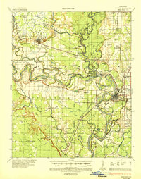 1935 Newport1937 Print · USGSJackson and Independence counties are captured here in the mid-1930s as the river-and-rail economy shaped local life. Genealogists can trace family landmarks like MeGuire Cem and Griffin Sch, while historians can locate the old river port at Jacksonport.2 unique versions available
 - 1935 Map of Tuckerman, 1946 Print
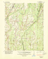 1935 Tuckerman1946 Print · USGSNortheast Arkansas in the mid-thirties was a landscape shaped by the Cache River and a dense network of drainage ditches. Family historians can trace rural roots through numerous combined sites like Antioch Ch & Cem and Green Haw Sch & Cem.2 unique versions available
End of results
Showing maps 1-2 of 2
Top cities near Campbell Station
- Newport historical maps
- Tuckerman historical maps
- Diaz historical maps
- Newark historical maps
- Swifton historical maps
- Grubbs historical maps
See more
Frequently asked questions
- What are the different types of historical maps available for Campbell Station?
- What is the oldest map of Campbell Station?
- Where can I purchase historical maps of Campbell Station for my home or office?
- Where can I download high-res historical maps of Campbell Station?
- Are there historical topographic maps available for Campbell Station?
- Is there historical aerial imagery available for Campbell Station?
- Where are historical maps of Campbell Station sourced from?