1900s (20th Century) Maps of Marianna, Arkansas
Explore 15 historic maps of Marianna from the 1900s (20th Century). These maps offer a rare glimpse into what life looked like during the 1900s — showing old roads, neighborhoods, homes, and landmarks that have changed or disappeared over time.
Whether you're researching your family's past, planning a metal detecting trip, or studying how Marianna's landscape evolved across the 1900s, these high-resolution maps are a powerful tool for exploring the history of this region.
- Focus on a specific era: All maps on this page are from the 1900s, giving you a focused view of this time period.
- See what’s changed: Compare century-old streets, trails, and buildings to today's modern landscape using overlays and satellite layers.
- Research with precision: Use these maps for genealogy, historical research, land use analysis, or educational projects.
- View, download, or print: Maps are fully viewable online in high resolution, and can be downloaded or printed for your own records.
Start exploring Marianna's history through authentic maps from the 1900s. This is your window into the past.
Marianna, AR maps
(15)- 1939 Map of Park Place, 1941 Print
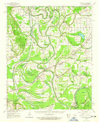
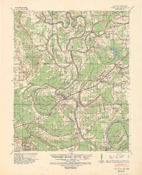 1939 Park Place1941 Print · USGSThe Arkansas delta near the St. Francis and L'Anguille Rivers is shown here in the late 1930s as a thriving rail and river landscape. Genealogists can locate family names and rural centers like True Love Bar Ch & Sch, Rollinson, and the Marianna Helena Land Project.2 unique versions available
 - 1940 Map of Marianna, 1942 Print
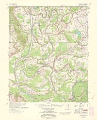
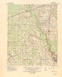 1940 Marianna1942 Print · USGSEastern Arkansas at the start of the 1940s is captured here in a landscape of river-bottom farms and rail-line towns. Researchers can locate numerous local landmarks including Scruggs Chapel, the Haunted Cem, and the river crossing at Felton.2 unique versions available
 - 1948 Map of Helena
 1948 Helena1948 Print · USGSEastern Arkansas and the Mississippi Delta are captured here just after the war, showing a landscape defined by its great rivers and rail lines. Genealogists can trace family locations near Bemis Plantation, Helena, and smaller rail stops like Wheatley and Moro.
 - 1950 Map of Helena
 1950 Helena1950 Print · USGSMid-century Phillips County and the surrounding Delta region are shown at a peak of rail and river commerce. Genealogists and historians can trace family locations through numerous rural communities like Old Austin, Cotton Plant, and West Helena, or follow the routes of the Missouri Pacific RR across Grand Prairie.2 unique versions available
 - 1955 Map of Park Place
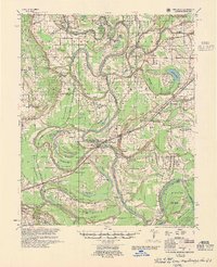 1955 Park Place1955 Print · USGSThe St. Francis River basin in the 1950s is a world of bayous, river landings, and family-centered rural communities. Genealogists can trace hundreds of specific sites including Soudan Ldg, True Love Crossing, and Macedonia Ch among the oxbow lakes.2 unique versions available
 - 1955 Map of Helena, 1967 Print
 1955 Helena1967 Print · USGSThe Arkansas Delta and Mississippi floodplains are captured here in the mid-fifties, during a period of expanding flood control and rail commerce. Researchers can trace the extensive Chicago Rock Island and Pacific RR lines and locate sites like the Arkansas State College Experimental Rice Farm or Friars Point.2 unique versions available
 - 1957 Map of Marianna
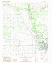
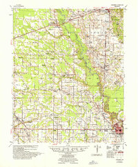 1957 Marianna1957 Print · USGSLee County's agricultural heartland is documented here in the mid-fifties, showing the intersection of rail lines and river commerce. Genealogists can trace family landmarks at Mars Hill Ch & Cem, Holub Crossing, and the rural community at Oak Forest.2 unique versions available
 - 1959 Map of Helena
 1959 Helena1959 Print · USGSThe Arkansas and Mississippi Delta regions are captured here in the late fifties, showing a landscape defined by the Mississippi River and the Grand Prairie. Genealogists and researchers can trace the rail networks of the Illinois Central RR and locate community landmarks like Helena and the White River National Wildlife Refuge.
 - 1960 Map of Helena
 1960 Helena1960 Print · USGSThe Arkansas and Mississippi Delta regions meet along the great river bends during a period of significant agricultural and rail expansion. Genealogists and historians can trace the paths of the Missouri Pacific railroad through Clarendon or locate landings along the Mississippi River and White River.
 - 1962 Map of Park Place, 1965 Print
 1962 Park Place1965 Print · USGSEastern Arkansas river country is mapped here in the early sixties, showing the complex oxbows of the St Francis River. Researchers can trace old family sites and rural landmarks like Soudan Cem, Brickeys, and the rail stops of the Missouri Pacific.2 unique versions available
 - 1963 Map of Park Place
 1963 Park Place1963 Print · USGSLee County, Arkansas, at the start of the sixties reveals a river-driven landscape shaped by the St Francis River and its floodway. Local historians can trace established communities like Brickeys and find numerous country churches and cemeteries, including Gospel Temple and Soudan Cem.
 - 1984 Map of Helena, 1985 Print
 1984 Helena1985 Print · USGSThe Delta landscape of Arkansas and Mississippi comes to life in this mid-eighties survey of river bends and ridge settlements. Researchers can trace the rail-and-river economy through Missouri Pacific lines and local landmarks like Whiskey Island or Marianna.
 - 1984 Map of Marianna, 1985 Print
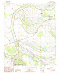
 1984 Marianna1985 Print · USGSThe Arkansas Delta comes into focus in the mid-1980s, centered on the river town of Marianna. Genealogists and local historians can trace rural family sites near Wrightland, Canaan, and the winding L' Anguille River.2 unique versions available
 - 1984 Map of Soudan, 1985 Print
 1984 Soudan1985 Print · USGSLee County, Arkansas, is captured in the early 1980s as the river-driven landscape of the Delta meets the heights of the ridges. Genealogists and local historians can trace the areas around Soudan and Cody, or locate family landmarks near Big Yancopin Lake and Skidmore Ridge.
 - 1990 Map of Helena, 1991 Print
 1990 Helena1991 Print · USGSThe Arkansas and Mississippi delta regions meet here in the 1990s, where the great river's oxbows and islands define the state line. Genealogists and historians can trace the rail networks of the Illinois Central Gulf RR and local settlements like Palestine, Marvell, and La Grange.
End of results
Showing maps 1-15 of 15
Top cities near Marianna
- Forrest City historical maps
- Helena-West Helena historical maps
- Marvell historical maps
- Palestine historical maps
- Lexa historical maps
- Moro historical maps
See more
Frequently asked questions
- What are the different types of historical maps available for Marianna?
- What is the oldest map of Marianna?
- Where can I purchase historical maps of Marianna for my home or office?
- Where can I download high-res historical maps of Marianna?
- Are there historical topographic maps available for Marianna?
- Is there historical aerial imagery available for Marianna?
- Where are historical maps of Marianna sourced from?