1980s Maps of Moro, Arkansas
Explore 2 historic maps of Moro from the 1980s. These maps offer a rare glimpse into what life looked like during the 1980s — showing old roads, neighborhoods, homes, and landmarks that have changed or disappeared over time.
Whether you're researching your family's past, planning a metal detecting trip, or studying how Moro's landscape evolved across the 1980s, these high-resolution maps are a powerful tool for exploring the history of this region.
- Focus on a specific era: All maps on this page are from the 1980s, giving you a focused view of this time period.
- See what’s changed: Compare century-old streets, trails, and buildings to today's modern landscape using overlays and satellite layers.
- Research with precision: Use these maps for genealogy, historical research, land use analysis, or educational projects.
- View, download, or print: Maps are fully viewable online in high resolution, and can be downloaded or printed for your own records.
Start exploring Moro's history through authentic maps from the 1980s. This is your window into the past.
Moro, AR maps
(2)- 1984 Map of Helena, 1985 Print
 1984 Helena1985 Print · USGSThe Delta landscape of Arkansas and Mississippi comes to life in this mid-eighties survey of river bends and ridge settlements. Researchers can trace the rail-and-river economy through Missouri Pacific lines and local landmarks like Whiskey Island or Marianna.
 - 1984 Map of Moro, 1985 Print
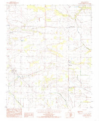 1984 Moro1985 Print · USGSIn the mid-1980s, this Lee County landscape was defined by small farming communities and winding waterways. Genealogists and local historians can trace the rural layout of Moro and find family landmarks at Oak Forest Cem or Smith Corner.
End of results
Showing maps 1-2 of 2
Top cities near Moro
- Forrest City historical maps
- Marianna historical maps
- Brinkley historical maps
- Palestine historical maps
- Holly Grove historical maps
- Wheatley historical maps
See more
Frequently asked questions
- What are the different types of historical maps available for Moro?
- What is the oldest map of Moro?
- Where can I purchase historical maps of Moro for my home or office?
- Where can I download high-res historical maps of Moro?
- Are there historical topographic maps available for Moro?
- Is there historical aerial imagery available for Moro?
- Where are historical maps of Moro sourced from?