1970s Maps of Blytheville, Arkansas
Explore 3 historic maps of Blytheville from the 1970s. These maps offer a rare glimpse into what life looked like during the 1970s — showing old roads, neighborhoods, homes, and landmarks that have changed or disappeared over time.
Whether you're researching your family's past, planning a metal detecting trip, or studying how Blytheville's landscape evolved across the 1970s, these high-resolution maps are a powerful tool for exploring the history of this region.
- Focus on a specific era: All maps on this page are from the 1970s, giving you a focused view of this time period.
- See what’s changed: Compare century-old streets, trails, and buildings to today's modern landscape using overlays and satellite layers.
- Research with precision: Use these maps for genealogy, historical research, land use analysis, or educational projects.
- View, download, or print: Maps are fully viewable online in high resolution, and can be downloaded or printed for your own records.
Start exploring Blytheville's history through authentic maps from the 1970s. This is your window into the past.
Blytheville, AR maps
(3)- 1972 Map of Armorel, 1974 Print
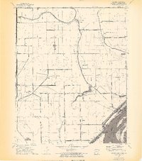 1972 Armorel1974 Print · USGSThe tri-state border region of Arkansas, Missouri, and Tennessee comes alive in this survey of the riverlands and drainage districts. Genealogists and local historians can trace family roots through rural landmarks like Number Nine, Promised Land, and New Mt Nebo Ch.4 unique versions available
 - 1972 Map of Blytheville, 1974 Print
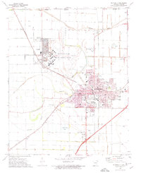 1972 Blytheville1974 Print · USGSBlytheville and the surrounding Delta farm country are captured here in the early seventies during the height of the Cold War. Genealogists and local historians can trace family locations near Mt Zion Cem, the massive Blytheville Air Force Base, and rural schools like Fairview Sch.2 unique versions available
 - 1976 Map of Blytheville
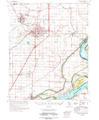 1976 Blytheville1976 Print · USGSBlytheville and the Mississippi River Delta are captured here in the mid-seventies, showing a landscape defined by military aviation and river commerce. Genealogists and researchers can locate family sites at Memorial Park Cem, trace the vanished streets of Yarbro, or explore the extensive Blytheville Air Force Base.
End of results
Showing maps 1-3 of 3
Top cities near Blytheville
- Osceola historical maps
- Caruthersville historical maps
- Gosnell historical maps
- Steele historical maps
- Luxora historical maps
- Hornersville historical maps
See more
Top neighborhoods of Blytheville
Frequently asked questions
- What are the different types of historical maps available for Blytheville?
- What is the oldest map of Blytheville?
- Where can I purchase historical maps of Blytheville for my home or office?
- Where can I download high-res historical maps of Blytheville?
- Are there historical topographic maps available for Blytheville?
- Is there historical aerial imagery available for Blytheville?
- Where are historical maps of Blytheville sourced from?