1900s (20th Century) Maps of Etowah, Arkansas
Explore 9 historic maps of Etowah from the 1900s (20th Century). These maps offer a rare glimpse into what life looked like during the 1900s — showing old roads, neighborhoods, homes, and landmarks that have changed or disappeared over time.
Whether you're researching your family's past, planning a metal detecting trip, or studying how Etowah's landscape evolved across the 1900s, these high-resolution maps are a powerful tool for exploring the history of this region.
- Focus on a specific era: All maps on this page are from the 1900s, giving you a focused view of this time period.
- See what’s changed: Compare century-old streets, trails, and buildings to today's modern landscape using overlays and satellite layers.
- Research with precision: Use these maps for genealogy, historical research, land use analysis, or educational projects.
- View, download, or print: Maps are fully viewable online in high resolution, and can be downloaded or printed for your own records.
Start exploring Etowah's history through authentic maps from the 1900s. This is your window into the past.
Etowah, AR maps
(9)- 1939 Map of Evadale, 1954 Print
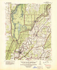
 1939 Evadale1954 Print · USGSMississippi County, Arkansas, at the end of the 1930s was a landscape being reshaped by the drainage of the Sunk Lands. Local historians can trace the foundations of several communities and rural landmarks, including Little Bethlehem Ch & Cem, the company town of Wilson, and the early settlement of Dyess.
 - 1941 Map of Marked Tree, 1946 Print
 1941 Marked Tree1946 Print · USGSPoinsett County at the start of the 1940s reveals a landscape of massive drainage projects and river engineering. Trace the early footprints of Marked Tree and Lepanto alongside rural landmarks like Frys Mill, Pilgrims Rest Ch, and the Spear Lake Sch & Cem.2 unique versions available
 - 1953 Map of Memphis, 1966 Print
 1953 Memphis1966 Print · USGSEastern Arkansas and the Memphis riverfront are shown here during the mid-century period of regional growth and river management. Local historians can trace the paths of the Chicago Rock Island & Pacific RR through Forrest City or locate river landmarks like President's Island.3 unique versions available
 - 1956 Map of Evadale
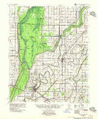
 1956 Evadale1956 Print · USGSMississippi County, Arkansas, appears in the early 1950s as a productive agricultural landscape secured by an extensive system of levees and drainage ditches. Genealogists can locate family names at Pittman Cem, Louise Chapel & Cem, and the industry at Creamery Package.
 - 1956 Map of Marked Tree
 1956 Marked Tree1956 Print · USGSThe Arkansas Delta comes into focus in the mid-1950s as drainage projects transformed the Sunk Lands for agriculture. Researchers can trace the junction of the St Louis Southwestern RR and locate local landmarks like the Hatchie Coon Hunting Lodge and Nichols Cem.2 unique versions available
 - 1956 Map of Memphis
 1956 Memphis1956 Print · USGSThe Mississippi Delta and the bluffs of West Tennessee meet in the mid-fifties, showing a landscape defined by massive river systems and rail hubs. Researchers can trace the path of Crowleys Ridge or locate vanished river landings near Centennial Island and Island No 35.
 - 1983 Map of Etowah, 1984 Print
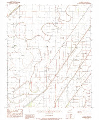 1983 Etowah1984 Print · USGSMississippi County in the early eighties shows an engineered delta landscape of drainage canals and small farming hubs. Genealogists can locate family landmarks like Gant Cem and rural centers such as Etowah, Bondsville, and Athelstan.
 - 1983 Map of Rivervale, 1984 Print
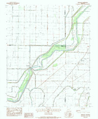 1983 Rivervale1984 Print · USGSNortheast Arkansas in the early eighties was a landscape of intensive water management where the Little River splits into its divergent chutes. Researchers can trace rural settlement patterns at Rivervale and West Ridge or locate local landmarks like Buffalo Ch and Helfer Landing.
 - 1986 Map of Jonesboro
 1986 Jonesboro1986 Print · USGSNortheast Arkansas in the mid-eighties shows a landscape of intensive drainage and railroad junctions centered on the rise of Crowley's Ridge. Researchers can trace the rail corridors of the St Louis Southwestern Railway and explore the unique geography of Hatchie Coon Island and the Mississippi River floodplain.2 unique versions available
End of results
Showing maps 1-9 of 9
Top cities near Etowah
- Osceola historical maps
- Manila historical maps
- Marked Tree historical maps
- Leachville historical maps
- Lake City historical maps
- Lepanto historical maps
See more
Top neighborhoods of Etowah
Frequently asked questions
- What are the different types of historical maps available for Etowah?
- What is the oldest map of Etowah?
- Where can I purchase historical maps of Etowah for my home or office?
- Where can I download high-res historical maps of Etowah?
- Are there historical topographic maps available for Etowah?
- Is there historical aerial imagery available for Etowah?
- Where are historical maps of Etowah sourced from?