1900s (20th Century) Maps of Osceola, Arkansas
Explore 13 historic maps of Osceola from the 1900s (20th Century). These maps offer a rare glimpse into what life looked like during the 1900s — showing old roads, neighborhoods, homes, and landmarks that have changed or disappeared over time.
Whether you're researching your family's past, planning a metal detecting trip, or studying how Osceola's landscape evolved across the 1900s, these high-resolution maps are a powerful tool for exploring the history of this region.
- Focus on a specific era: All maps on this page are from the 1900s, giving you a focused view of this time period.
- See what’s changed: Compare century-old streets, trails, and buildings to today's modern landscape using overlays and satellite layers.
- Research with precision: Use these maps for genealogy, historical research, land use analysis, or educational projects.
- View, download, or print: Maps are fully viewable online in high resolution, and can be downloaded or printed for your own records.
Start exploring Osceola's history through authentic maps from the 1900s. This is your window into the past.
Osceola, AR maps
(13)- 1939 Map of Evadale, 1954 Print
 1939 Evadale1954 Print · USGSMississippi County, Arkansas, at the end of the 1930s was a landscape being reshaped by the drainage of the Sunk Lands. Local historians can trace the foundations of several communities and rural landmarks, including Little Bethlehem Ch & Cem, the company town of Wilson, and the early settlement of Dyess.
 - 1953 Map of Memphis, 1966 Print
 1953 Memphis1966 Print · USGSEastern Arkansas and the Memphis riverfront are shown here during the mid-century period of regional growth and river management. Local historians can trace the paths of the Chicago Rock Island & Pacific RR through Forrest City or locate river landmarks like President's Island.3 unique versions available
 - 1956 Map of Evadale
 1956 Evadale1956 Print · USGSMississippi County, Arkansas, appears in the early 1950s as a productive agricultural landscape secured by an extensive system of levees and drainage ditches. Genealogists can locate family names at Pittman Cem, Louise Chapel & Cem, and the industry at Creamery Package.
 - 1956 Map of Memphis
 1956 Memphis1956 Print · USGSThe Mississippi Delta and the bluffs of West Tennessee meet in the mid-fifties, showing a landscape defined by massive river systems and rail hubs. Researchers can trace the path of Crowleys Ridge or locate vanished river landings near Centennial Island and Island No 35.
 - 1956 Map of Blytheville, 1964 Print
 1956 Blytheville1964 Print · USGSWest Tennessee and the Arkansas Delta come alive in this mid-century survey of the river-and-rail corridor connecting Memphis to Jackson. Genealogists and historians can trace the rail lines of the Louisville and Nashville RR and locate landmarks like Western State Hospital or Fort Pillow State Prison Farm.2 unique versions available
 - 1959 Map of Blytheville
 1959 Blytheville1959 Print · USGSWest Tennessee and Northeast Arkansas meet along the river in the late fifties, during a period of steady industrial and agricultural growth. Genealogists can trace the rail corridors of the Illinois Central through Jackson or explore landmarks like Shiloh National Military Park and Fort Pillow State Prison.
 - 1963 Map of Osceola, 1966 Print
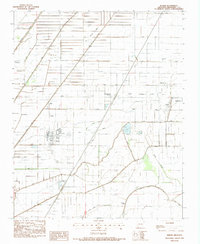
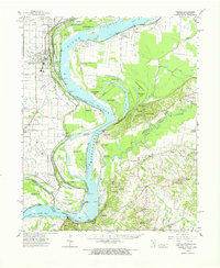 1963 Osceola1966 Print · USGSThe river borders of Tennessee and Arkansas meet along the bends of the Mississippi in the early sixties. Genealogists and historians can trace riverside settlements like Golddust and Randolph, or locate rural landmarks like Raven Cross Cem and St Johns Ch.
 - 1965 Map of Osceola
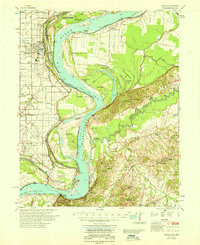 1965 Osceola1965 Print · USGSOsceola and the Mississippi River bottomlands are captured here in the mid-sixties, showing the complex boundary between Arkansas and Tennessee. Researchers can trace family roots through numerous rural landmarks like Golddust Ch & Sch, Grider, and Smyrna Ch.
 - 1972 Map of Osceola, 1975 Print
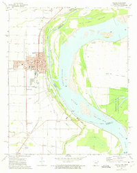 1972 Osceola1975 Print · USGSOsceola sits on the edge of the Mississippi River in the early 1970s, a landscape shaped by both the river and the St. Louis - San Francisco railway. Genealogists and local historians can trace family roots through several landmarks like Violet Cem, Ermen Lane Washington Cem, and the settlement of Grider.2 unique versions available
 - 1977 Map of Osceola
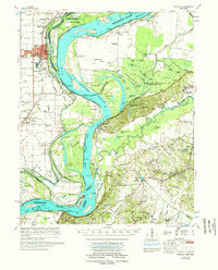 1977 Osceola1977 Print · USGSThe Mississippi Delta's winding riverborder comes alive in the 1970s, showing the complex interaction of the Mississippi River and the riverfront communities. Genealogists and local historians can locate many rural landmarks, from Nodena Cem and Mississippi County Memorial Gardens to the river-bluff heights of Fort Pillow State Park.
 - 1983 Map of Keiser, 1984 Print
 1983 Keiser1984 Print · USGSMississippi County, Arkansas, appears in the early eighties as a highly organized agricultural landscape crisscrossed by essential drainage channels. Genealogists and local historians can locate rural landmarks like Zion Rock Cem, Keiser Chapel, and the settlement of Cottonwood Corner.
 - 1986 Map of Jonesboro
 1986 Jonesboro1986 Print · USGSNortheast Arkansas in the mid-eighties shows a landscape of intensive drainage and railroad junctions centered on the rise of Crowley's Ridge. Researchers can trace the rail corridors of the St Louis Southwestern Railway and explore the unique geography of Hatchie Coon Island and the Mississippi River floodplain.2 unique versions available
 - 1986 Map of Blytheville
 1986 Blytheville1986 Print · USGSThe Arkansas-Tennessee borderlands appear here in the mid-eighties, centered on the mighty Mississippi River and its shifting islands. Trace the footprints of Blytheville Air Force Base, old river towns like Golddust, and the extensive grounds of the Fort Pillow State Prison Farm.2 unique versions available
End of results
Showing maps 1-13 of 13
Top cities near Osceola
- Blytheville historical maps
- Atoka historical maps
- Munford historical maps
- Manila historical maps
- Leachville historical maps
- Luxora historical maps
See more
Top neighborhoods of Osceola
Frequently asked questions
- What are the different types of historical maps available for Osceola?
- What is the oldest map of Osceola?
- Where can I purchase historical maps of Osceola for my home or office?
- Where can I download high-res historical maps of Osceola?
- Are there historical topographic maps available for Osceola?
- Is there historical aerial imagery available for Osceola?
- Where are historical maps of Osceola sourced from?