1980s Maps of Osceola, Arkansas
Explore 3 historic maps of Osceola from the 1980s. These maps offer a rare glimpse into what life looked like during the 1980s — showing old roads, neighborhoods, homes, and landmarks that have changed or disappeared over time.
Whether you're researching your family's past, planning a metal detecting trip, or studying how Osceola's landscape evolved across the 1980s, these high-resolution maps are a powerful tool for exploring the history of this region.
- Focus on a specific era: All maps on this page are from the 1980s, giving you a focused view of this time period.
- See what’s changed: Compare century-old streets, trails, and buildings to today's modern landscape using overlays and satellite layers.
- Research with precision: Use these maps for genealogy, historical research, land use analysis, or educational projects.
- View, download, or print: Maps are fully viewable online in high resolution, and can be downloaded or printed for your own records.
Start exploring Osceola's history through authentic maps from the 1980s. This is your window into the past.
Osceola, AR maps
(3)- 1983 Map of Keiser, 1984 Print
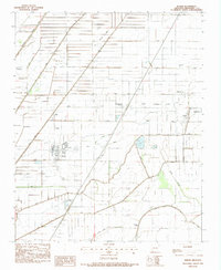 1983 Keiser1984 Print · USGSMississippi County, Arkansas, appears in the early eighties as a highly organized agricultural landscape crisscrossed by essential drainage channels. Genealogists and local historians can locate rural landmarks like Zion Rock Cem, Keiser Chapel, and the settlement of Cottonwood Corner.
 - 1986 Map of Jonesboro
 1986 Jonesboro1986 Print · USGSNortheast Arkansas in the mid-eighties shows a landscape of intensive drainage and railroad junctions centered on the rise of Crowley's Ridge. Researchers can trace the rail corridors of the St Louis Southwestern Railway and explore the unique geography of Hatchie Coon Island and the Mississippi River floodplain.2 unique versions available
 - 1986 Map of Blytheville
 1986 Blytheville1986 Print · USGSThe Arkansas-Tennessee borderlands appear here in the mid-eighties, centered on the mighty Mississippi River and its shifting islands. Trace the footprints of Blytheville Air Force Base, old river towns like Golddust, and the extensive grounds of the Fort Pillow State Prison Farm.2 unique versions available
End of results
Showing maps 1-3 of 3
Top cities near Osceola
- Blytheville historical maps
- Atoka historical maps
- Munford historical maps
- Manila historical maps
- Leachville historical maps
- Luxora historical maps
See more
Top neighborhoods of Osceola
Frequently asked questions
- What are the different types of historical maps available for Osceola?
- What is the oldest map of Osceola?
- Where can I purchase historical maps of Osceola for my home or office?
- Where can I download high-res historical maps of Osceola?
- Are there historical topographic maps available for Osceola?
- Is there historical aerial imagery available for Osceola?
- Where are historical maps of Osceola sourced from?