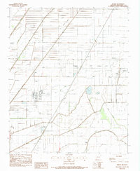
1983 Map of Keiser
USGS Topo · Published 1984About this map
Keiser stands as a central hub in this Mississippi County agricultural landscape, surrounded by an intricate network of drainage systems such as Ditch No 47 and Ditch No 48. The map reveals a high density of rural cemeteries and churches that anchor the local community, including Union Valley Cem and Little Bethlehem Ch. To the east, the Osceola Corporate Boundary marks the edge of the regional center, home to the Osceola Airport and Osceola High Sch. The terrain is defined by its water management history, where natural features like Sandy Bayou and Waller Bayou are integrated into a geometric grid of man-made channels. Smaller named settlements like Shippen, Pace, and Red Line represent the smaller residential clusters that supported the area's intensive farming economy during the late twentieth century.
Find a feature on this map
46 named features on this map. Tap any name to fly to it.
Don’t see what you’re looking for? This feature index may not catch every label — zoom into the map to look around manually.
Map Details
Editions of this 1983 Keiser Map
This is the sole edition of this map. No revisions or reprints were ever made.
Other maps of this area

1939 · Blytheville
USGS Topo · 1:62,500

1939 · Evadale
USGS Topo · 1:62,500

1941 · Manila
USGS Topo · 1:62,500

1953 · Memphis
USGS Topo · 1:250,000

1955 · Blytheville
USGS Topo · 1:62,500

1956 · Manila
USGS Topo · 1:62,500

1956 · Evadale
USGS Topo · 1:62,500

1956 · Memphis
USGS Topo · 1:250,000

1956 · Blytheville
USGS Topo · 1:250,000

1959 · Blytheville
USGS Topo · 1:250,000