1970s Maps of Deep Elm, Arkansas
Explore 2 historic maps of Deep Elm from the 1970s. These maps offer a rare glimpse into what life looked like during the 1970s — showing old roads, neighborhoods, homes, and landmarks that have changed or disappeared over time.
Whether you're researching your family's past, planning a metal detecting trip, or studying how Deep Elm's landscape evolved across the 1970s, these high-resolution maps are a powerful tool for exploring the history of this region.
- Focus on a specific era: All maps on this page are from the 1970s, giving you a focused view of this time period.
- See what’s changed: Compare century-old streets, trails, and buildings to today's modern landscape using overlays and satellite layers.
- Research with precision: Use these maps for genealogy, historical research, land use analysis, or educational projects.
- View, download, or print: Maps are fully viewable online in high resolution, and can be downloaded or printed for your own records.
Start exploring Deep Elm's history through authentic maps from the 1970s. This is your window into the past.
Deep Elm, AR maps
(2)- 1971 Map of Holly Grove, 1973 Print
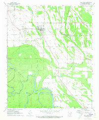 1971 Holly Grove1973 Print · USGSThe town of Holly Grove and the settlement at Lawrenceville are captured here in the early seventies, connected by the Missouri Pacific rail line. Trace family roots at Travelers Rest Cem, Redmans Cem, or Mt Zion Ch among the sloughs and bayous.
 - 1974 Map of Holly Grove
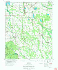 1974 Holly Grove1974 Print · USGSEastern Arkansas at the start of the 1970s reveals a landscape of specialized aquaculture and historic survey points. Genealogists and historians can trace numerous rural congregations and burial sites like Big Star Ch, Postelle Cem, and the Louisiana Purchase Monument.
End of results
Showing maps 1-2 of 2
Top cities near Deep Elm
- Clarendon historical maps
- Holly Grove historical maps
- Saint Charles historical maps
- Roe historical maps
Frequently asked questions
- What are the different types of historical maps available for Deep Elm?
- What is the oldest map of Deep Elm?
- Where can I purchase historical maps of Deep Elm for my home or office?
- Where can I download high-res historical maps of Deep Elm?
- Are there historical topographic maps available for Deep Elm?
- Is there historical aerial imagery available for Deep Elm?
- Where are historical maps of Deep Elm sourced from?