1970s Maps of Bluff City, Arkansas
Explore 3 historic maps of Bluff City from the 1970s. These maps offer a rare glimpse into what life looked like during the 1970s — showing old roads, neighborhoods, homes, and landmarks that have changed or disappeared over time.
Whether you're researching your family's past, planning a metal detecting trip, or studying how Bluff City's landscape evolved across the 1970s, these high-resolution maps are a powerful tool for exploring the history of this region.
- Focus on a specific era: All maps on this page are from the 1970s, giving you a focused view of this time period.
- See what’s changed: Compare century-old streets, trails, and buildings to today's modern landscape using overlays and satellite layers.
- Research with precision: Use these maps for genealogy, historical research, land use analysis, or educational projects.
- View, download, or print: Maps are fully viewable online in high resolution, and can be downloaded or printed for your own records.
Start exploring Bluff City's history through authentic maps from the 1970s. This is your window into the past.
Bluff City, AR maps
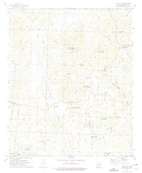
(3)- 1973 Map of Chidester, 1975 Print
 1973 Chidester1975 Print · USGSOuachita and Nevada counties are captured in the early 1970s, as the timberlands and recreation around White Oak Lake took shape. Researchers can locate community centers like Chidester and Good Hope, or trace family roots at Turner Cem and Mt Moriah Ch.
 - 1973 Map of Bluff City, 1975 Print
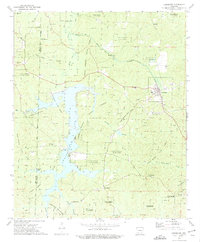
 1973 Bluff City1975 Print · USGSSouth-central Arkansas forestry and rural life are captured here in the early 1970s. Researchers can locate family landmarks like Dills Mills and Barham, trace the Reader railroad, or find historic congregations at Ebenezer Ch and St Johns Ch.
 - 1978 Map of Chidester
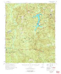 1978 Chidester1978 Print · USGSThe Poison Springs State Forest and the waters of White Oak Lake characterize this late-seventies landscape on the Nevada and Ouachita county line. Researchers can locate numerous rural landmarks like Dills Mills, Adams Chapel Cem, and Anthony Switch.
End of results
Showing maps 1-3 of 3
Top cities near Bluff City
- Gurdon historical maps
- Chidester historical maps
- Rosston historical maps
- Willisville historical maps
- Cale historical maps
- Whelen Springs historical maps
Frequently asked questions
- What are the different types of historical maps available for Bluff City?
- What is the oldest map of Bluff City?
- Where can I purchase historical maps of Bluff City for my home or office?
- Where can I download high-res historical maps of Bluff City?
- Are there historical topographic maps available for Bluff City?
- Is there historical aerial imagery available for Bluff City?
- Where are historical maps of Bluff City sourced from?