1970s Maps of Troy, Arkansas
Explore 2 historic maps of Troy from the 1970s. These maps offer a rare glimpse into what life looked like during the 1970s — showing old roads, neighborhoods, homes, and landmarks that have changed or disappeared over time.
Whether you're researching your family's past, planning a metal detecting trip, or studying how Troy's landscape evolved across the 1970s, these high-resolution maps are a powerful tool for exploring the history of this region.
- Focus on a specific era: All maps on this page are from the 1970s, giving you a focused view of this time period.
- See what’s changed: Compare century-old streets, trails, and buildings to today's modern landscape using overlays and satellite layers.
- Research with precision: Use these maps for genealogy, historical research, land use analysis, or educational projects.
- View, download, or print: Maps are fully viewable online in high resolution, and can be downloaded or printed for your own records.
Start exploring Troy's history through authentic maps from the 1970s. This is your window into the past.
Troy, AR maps
(2)- 1973 Map of Troy, 1975 Print
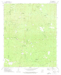 1973 Troy1975 Print · USGSThe Ouachita and Nevada county lines intersect in this forested Arkansas landscape during the early 1970s. Genealogists and historians can trace numerous rural congregations and burial sites, including Adams Chapel, Round Oak Cem, and the East Troy Oil Field.
 - 1978 Map of Chidester
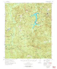 1978 Chidester1978 Print · USGSThe Poison Springs State Forest and the waters of White Oak Lake characterize this late-seventies landscape on the Nevada and Ouachita county line. Researchers can locate numerous rural landmarks like Dills Mills, Adams Chapel Cem, and Anthony Switch.
End of results
Showing maps 1-2 of 2
Top cities near Troy
- Camden historical maps
- Magnolia historical maps
- Waldo historical maps
- Stephens historical maps
- McNeil historical maps
- Chidester historical maps
See more
Frequently asked questions
- What are the different types of historical maps available for Troy?
- What is the oldest map of Troy?
- Where can I purchase historical maps of Troy for my home or office?
- Where can I download high-res historical maps of Troy?
- Are there historical topographic maps available for Troy?
- Is there historical aerial imagery available for Troy?
- Where are historical maps of Troy sourced from?