1970s Maps of Kindall, Arkansas
Explore 1 historic maps of Kindall from the 1970s. These maps offer a rare glimpse into what life looked like during the 1970s — showing old roads, neighborhoods, homes, and landmarks that have changed or disappeared over time.
Whether you're researching your family's past, planning a metal detecting trip, or studying how Kindall's landscape evolved across the 1970s, these high-resolution maps are a powerful tool for exploring the history of this region.
- Focus on a specific era: All maps on this page are from the 1970s, giving you a focused view of this time period.
- See what’s changed: Compare century-old streets, trails, and buildings to today's modern landscape using overlays and satellite layers.
- Research with precision: Use these maps for genealogy, historical research, land use analysis, or educational projects.
- View, download, or print: Maps are fully viewable online in high resolution, and can be downloaded or printed for your own records.
Start exploring Kindall's history through authentic maps from the 1970s. This is your window into the past.
Kindall, AR maps
(1)- 1971 Map of Lexa, 1973 Print
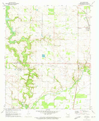 1971 Lexa1973 Print · USGSEastern Phillips County comes to life in the early seventies, centered on the railroad hub at Lexa and the farming communities of the Arkansas delta. Researchers can trace rural church history at St Johns Ch, locate ancestral plots at Mt Gilead Cem, and follow the Old RR Grade through the countryside.2 unique versions available
End of results
Showing maps 1-1 of 1
Top cities near Kindall
- Helena-West Helena historical maps
- Marianna historical maps
- Friars Point historical maps
- Marvell historical maps
- Lake View historical maps
- Lexa historical maps
See more
Frequently asked questions
- What are the different types of historical maps available for Kindall?
- What is the oldest map of Kindall?
- Where can I purchase historical maps of Kindall for my home or office?
- Where can I download high-res historical maps of Kindall?
- Are there historical topographic maps available for Kindall?
- Is there historical aerial imagery available for Kindall?
- Where are historical maps of Kindall sourced from?