1930s Maps of Siedenstricker, Arkansas
Explore 2 historic maps of Siedenstricker from the 1930s. These maps offer a rare glimpse into what life looked like during the 1930s — showing old roads, neighborhoods, homes, and landmarks that have changed or disappeared over time.
Whether you're researching your family's past, planning a metal detecting trip, or studying how Siedenstricker's landscape evolved across the 1930s, these high-resolution maps are a powerful tool for exploring the history of this region.
- Focus on a specific era: All maps on this page are from the 1930s, giving you a focused view of this time period.
- See what’s changed: Compare century-old streets, trails, and buildings to today's modern landscape using overlays and satellite layers.
- Research with precision: Use these maps for genealogy, historical research, land use analysis, or educational projects.
- View, download, or print: Maps are fully viewable online in high resolution, and can be downloaded or printed for your own records.
Start exploring Siedenstricker's history through authentic maps from the 1930s. This is your window into the past.
Siedenstricker, AR maps
(2)- 1937 Map of Stuttgart
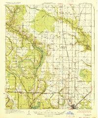 1937 Stuttgart1937 Print · USGSThe Grand Prairie region of Arkansas is captured here in the mid-1930s, showing the early infrastructure of the rice-growing heartland. Genealogists can trace family roots through numerous country schools and landmarks like Rice Junction, Slovac, and the Gum Pond Cem.3 unique versions available
 - 1939 Map of Stuttgart, 1947 Print
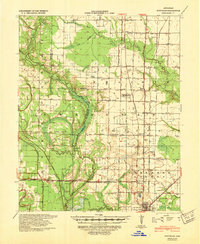 1939 Stuttgart1947 Print · USGSThe Grand Prairie region of Arkansas is captured here in the late 1930s, showing the agricultural heartland around the rail hub of Stuttgart. Genealogists and historians can trace defunct rural school districts like Fairmount Sch and Hamilton Sch or the early rail alignments of the St Louis Southwestern Ry.
End of results
Showing maps 1-2 of 2
Top cities near Siedenstricker
- Stuttgart historical maps
- Carlisle historical maps
- Hazen historical maps
- De Valls Bluff historical maps
- Fredonia (Biscoe) historical maps
- Humnoke historical maps
See more
Frequently asked questions
- What are the different types of historical maps available for Siedenstricker?
- What is the oldest map of Siedenstricker?
- Where can I purchase historical maps of Siedenstricker for my home or office?
- Where can I download high-res historical maps of Siedenstricker?
- Are there historical topographic maps available for Siedenstricker?
- Is there historical aerial imagery available for Siedenstricker?
- Where are historical maps of Siedenstricker sourced from?