1900s (20th Century) Maps of Reyno, Arkansas
Explore 10 historic maps of Reyno from the 1900s (20th Century). These maps offer a rare glimpse into what life looked like during the 1900s — showing old roads, neighborhoods, homes, and landmarks that have changed or disappeared over time.
Whether you're researching your family's past, planning a metal detecting trip, or studying how Reyno's landscape evolved across the 1900s, these high-resolution maps are a powerful tool for exploring the history of this region.
- Focus on a specific era: All maps on this page are from the 1900s, giving you a focused view of this time period.
- See what’s changed: Compare century-old streets, trails, and buildings to today's modern landscape using overlays and satellite layers.
- Research with precision: Use these maps for genealogy, historical research, land use analysis, or educational projects.
- View, download, or print: Maps are fully viewable online in high resolution, and can be downloaded or printed for your own records.
Start exploring Reyno's history through authentic maps from the 1900s. This is your window into the past.
Reyno, AR maps
(10)- 1935 Map of Knobel, 1938 Print
 1935 Knobel1938 Print · USGSDuring the mid-1930s, the Arkansas-Missouri borderlands were defined by the rail lines and river bends of the Black River valley. Researchers can trace family roots through Peach Orchard, Hopewell Ch, and cemeteries like Al McNaner Cem.
 - 1935 Map of Reyno, 1938 Print
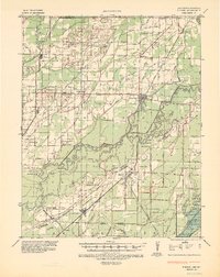
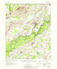
 1935 Reyno1938 Print · USGSRandolph and Clay counties are shown in the mid-1930s, documenting a river-dependent economy as the Ozarks meet the alluvial valley. Researchers can trace historic river crossings like Biggers Ferry and rural sites such as Johnson Cem and Cochrum Sch.3 unique versions available
 - 1941 Map of Knobel, 1946 Print
 1941 Knobel1946 Print · USGSClay County at the onset of the 1940s is defined by the winding Black River and the critical rail junctions that sustained its small towns. Researchers can trace family roots through numerous rural landmarks like Masterson Cem, Brazil Sch & Ch, and the river crossing at Bennetts Ferry Bridge.2 unique versions available
 - 1957 Map of Poplar Bluff, 1968 Print
 1957 Poplar Bluff1968 Print · USGSThe Missouri-Arkansas border region is captured here as the timber and rail industries shaped the Ozark foothills. Genealogists and historians can trace the Missouri Pacific Railroad through river towns like Pocahontas, Greenville, and Van Buren.3 unique versions available
 - 1959 Map of Poplar Bluff
 1959 Poplar Bluff1959 Print · USGSThe Missouri Ozarks and Arkansas borderlands meet in this late 1950s study of the region's diverse terrain and rail-fed towns. Researchers can trace the path of the Missouri Pacific Railroad through Poplar Bluff or locate smaller settlements like Birch Tree and Myrtle.
 - 1960 Map of Poplar Bluff
 1960 Poplar Bluff1960 Print · USGSSoutheast Missouri and Northeast Arkansas are captured here during the post-war era, showing the transition from the Ozark highlands to the Delta. Genealogists and historians can trace rail corridors like the St. Louis Southwestern RR and remote settlements such as Birch Tree and Warm Springs.
 - 1964 Map of Peach Orchard, 1965 Print
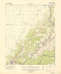
 1964 Peach Orchard1965 Print · USGSNortheast Arkansas in the mid-sixties is defined here by the winding channels of the Black River and the industrial backbone of two major railroads. Genealogists can locate family landmarks like Pirtle Ch, Allen Cem, and the small community of Brookings tucked along the riverbanks.3 unique versions available
 - 1967 Map of Knobel
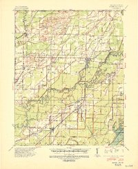
 1967 Knobel1967 Print · USGSNortheast Arkansas in the late 1960s reveals a landscape of river-bottom settlements and a sophisticated network of agricultural drainage. Trace the family roots of early residents near Corning, Success, and Knobel, or locate family sites at Richwoods Cem and Browns Chapel.
 - 1968 Map of Reyno, 1970 Print
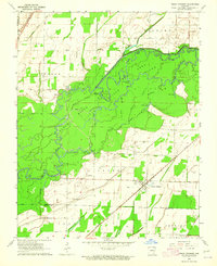
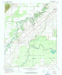 1968 Reyno1970 Print · USGSNortheast Arkansas river country is captured here in the late sixties, where the winding channels of the Current River define the local geography. Genealogists can trace family names through numerous burial sites like Old Reyno Cem and Yellow Hill Cem.2 unique versions available
 - 1984 Map of Paragould
 1984 Paragould1984 Print · USGSNortheast Arkansas and the Missouri Bootheel appear here in the mid-1980s as a landscape of ridge-top towns and engineered delta drainage. Genealogists and historians can locate rural landmarks like Oak Grove Church, trace the St Louis San Francisco RR, or explore the limits of Crowleys Ridge State Park.2 unique versions available
End of results
Showing maps 1-10 of 10
Top cities near Reyno
- Pocahontas historical maps
- Corning historical maps
- Naylor historical maps
- Maynard historical maps
- Biggers historical maps
- O'Kean historical maps
See more
Frequently asked questions
- What are the different types of historical maps available for Reyno?
- What is the oldest map of Reyno?
- Where can I purchase historical maps of Reyno for my home or office?
- Where can I download high-res historical maps of Reyno?
- Are there historical topographic maps available for Reyno?
- Is there historical aerial imagery available for Reyno?
- Where are historical maps of Reyno sourced from?