1970s Maps of Bryant, Arkansas
Explore 3 historic maps of Bryant from the 1970s. These maps offer a rare glimpse into what life looked like during the 1970s — showing old roads, neighborhoods, homes, and landmarks that have changed or disappeared over time.
Whether you're researching your family's past, planning a metal detecting trip, or studying how Bryant's landscape evolved across the 1970s, these high-resolution maps are a powerful tool for exploring the history of this region.
- Focus on a specific era: All maps on this page are from the 1970s, giving you a focused view of this time period.
- See what’s changed: Compare century-old streets, trails, and buildings to today's modern landscape using overlays and satellite layers.
- Research with precision: Use these maps for genealogy, historical research, land use analysis, or educational projects.
- View, download, or print: Maps are fully viewable online in high resolution, and can be downloaded or printed for your own records.
Start exploring Bryant's history through authentic maps from the 1970s. This is your window into the past.
Bryant, AR maps
(3)- 1974 Map of Benton, 1977 Print
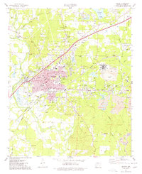 1974 Benton1977 Print · USGSBenton and the surrounding Saline County mining district are captured in the mid-seventies just as the aluminum industry and rail lines shaped the local economy. Researchers can locate family landmarks like Woodland Cem, early schools such as Perrin Sch, and the extensive Mine works near Bauxite.2 unique versions available
 - 1974 Map of Congo, 1977 Print
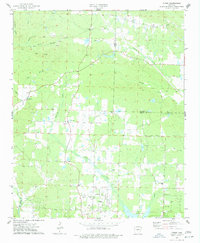 1974 Congo1977 Print · USGSThe Saline and Pulaski county line runs through this mid-1970s landscape of rural settlements and winding creeks. Researchers can trace family roots through numerous local landmarks, including Pipkin Cemetery, Congo Church, and the community of Avilla.3 unique versions available
 - 1975 Map of Alexander, 1976 Print
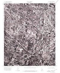 1975 Alexander1976 Print · USGSCentral Arkansas saw significant suburban expansion in the mid-seventies as the areas south of the capital grew. Genealogists and local historians can trace the early footprints of Little Rock, Alexander, and the community of Mabelvale.
End of results
Showing maps 1-3 of 3
Top cities near Bryant
- Little Rock historical maps
- North Little Rock historical maps
- Benton historical maps
- Maumelle historical maps
- Haskell historical maps
- Alexander historical maps
See more
Top neighborhoods of Bryant
- Springhill historical maps
- Careywood historical maps
- Edgewood historical maps
- Richardson Place historical maps
- Twin Oaks historical maps
- Evergreen historical maps
See more
Frequently asked questions
- What are the different types of historical maps available for Bryant?
- What is the oldest map of Bryant?
- Where can I purchase historical maps of Bryant for my home or office?
- Where can I download high-res historical maps of Bryant?
- Are there historical topographic maps available for Bryant?
- Is there historical aerial imagery available for Bryant?
- Where are historical maps of Bryant sourced from?