1940s Maps of Magic Springs, Arkansas
Explore 3 historic maps of Magic Springs from the 1940s. These maps offer a rare glimpse into what life looked like during the 1940s — showing old roads, neighborhoods, homes, and landmarks that have changed or disappeared over time.
Whether you're researching your family's past, planning a metal detecting trip, or studying how Magic Springs's landscape evolved across the 1940s, these high-resolution maps are a powerful tool for exploring the history of this region.
- Focus on a specific era: All maps on this page are from the 1940s, giving you a focused view of this time period.
- See what’s changed: Compare century-old streets, trails, and buildings to today's modern landscape using overlays and satellite layers.
- Research with precision: Use these maps for genealogy, historical research, land use analysis, or educational projects.
- View, download, or print: Maps are fully viewable online in high resolution, and can be downloaded or printed for your own records.
Start exploring Magic Springs's history through authentic maps from the 1940s. This is your window into the past.
Magic Springs, AR maps
(3)- 1941 Map of Snowball
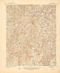 1941 Snowball1941 Print · USGSThe Buffalo River highlands of Searcy and Newton counties are shown here just before the Second World War. Genealogists and local historians can trace family roots through a dense network of country schools and churches, from Snowball to Faith Mission and the Welcome Home Sch.
 - 1942 Map of Snowball
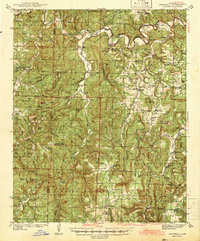 1942 Snowball1942 Print · USGSThe Ozark highlands of Newton and Searcy counties appear here in the late 1930s, showing a landscape defined by the Buffalo River. Genealogists can trace family roots through numerous remote sites like Hendrix Cem, Witt Springs, and Juanita Sch.
 - 1949 Map of Snowball
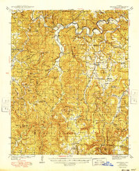 1949 Snowball1949 Print · USGSThe northern Arkansas highlands of the late 1940s are shown here in detail, from the banks of the Buffalo River to the small upland villages. Researchers can trace rural lineages through numerous landmarks like Dodson Cem, Snowball, and the Wasson Sch.
End of results
Showing maps 1-3 of 3
Top cities near Magic Springs
Frequently asked questions
- What are the different types of historical maps available for Magic Springs?
- What is the oldest map of Magic Springs?
- Where can I purchase historical maps of Magic Springs for my home or office?
- Where can I download high-res historical maps of Magic Springs?
- Are there historical topographic maps available for Magic Springs?
- Is there historical aerial imagery available for Magic Springs?
- Where are historical maps of Magic Springs sourced from?