1900s (20th Century) Maps of Ben Lomond, Arkansas
Explore 8 historic maps of Ben Lomond from the 1900s (20th Century). These maps offer a rare glimpse into what life looked like during the 1900s — showing old roads, neighborhoods, homes, and landmarks that have changed or disappeared over time.
Whether you're researching your family's past, planning a metal detecting trip, or studying how Ben Lomond's landscape evolved across the 1900s, these high-resolution maps are a powerful tool for exploring the history of this region.
- Focus on a specific era: All maps on this page are from the 1900s, giving you a focused view of this time period.
- See what’s changed: Compare century-old streets, trails, and buildings to today's modern landscape using overlays and satellite layers.
- Research with precision: Use these maps for genealogy, historical research, land use analysis, or educational projects.
- View, download, or print: Maps are fully viewable online in high resolution, and can be downloaded or printed for your own records.
Start exploring Ben Lomond's history through authentic maps from the 1900s. This is your window into the past.
Ben Lomond, AR maps
(8)- 1950 Map of Ben Lomond, 1966 Print
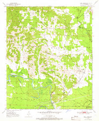 1950 Ben Lomond1966 Print · USGSMid-century Sevier and Little River counties appear here as a patchwork of river-bottom farms and small timber-country settlements. Genealogists and researchers can trace local roots at Rice Chapel, White Cliffs Sch, and the White Cliffs Station along the river.2 unique versions available
 - 1950 Map of Falls Chapel, 1973 Print
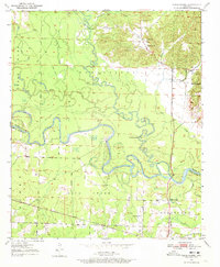 1950 Falls Chapel1973 Print · USGSThe river bottomlands of Sevier and Little River counties are captured here in the early postwar era, as the Cossatot River meanders toward its confluence. Genealogists can trace family landmarks like Hopson Cem and the Paraclifta Monument or the rail lines of the Kansas City Southern.2 unique versions available
 - 1951 Map of Ben Lomond
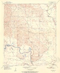 1951 Ben Lomond1951 Print · USGSSevier County and the Little River bottomlands are captured here in the early fifties during a period of steady rural development. Genealogists can trace family roots through landmarks like Rice Chapel, Brownstown Cemetery, and the White Cliffs School.2 unique versions available
 - 1951 Map of Falls Chapel
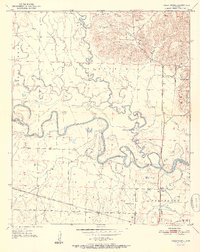 1951 Falls Chapel1951 Print · USGSSevier County bottomlands come into focus in the early 1950s where the river forks met the rail line. Genealogists can locate family landmarks like Hopson Cem, Pattors Store, and the site of the Paraclifta Monument.2 unique versions available
 - 1953 Map of Texarkana, 1964 Print
 1953 Texarkana1964 Print · USGSThe Texas-Arkansas borderlands are captured here in the mid-fifties, during a decade of massive military and hydraulic engineering projects. Genealogists and researchers can locate family landmarks like Old Boston Cem, Siloam Ch, and the vast Red River Arsenal.4 unique versions available
 - 1956 Map of Texarkana
 1956 Texarkana1956 Print · USGSThe Ark-La-Tex borderlands come alive in the mid-fifties, showing the transition from a rail-dependent rural economy to a post-war industrial landscape. Researchers can trace the massive Red River Ordnance Depot and find towns like Talco, Bogata, and Naples.
 - 1986 Map of Idabel
 1986 Idabel1986 Print · USGSThe tri-state borderlands of Oklahoma, Arkansas, and Texas come alive in the 1980s, centered on the Red River and the timberlands of the Ouachita National Forest. Genealogists and historians can trace the paths of the Missouri Pacific railroad through towns like Bokhoma and Ashdown.
 - 1990 Map of Idabel
 1990 Idabel1990 Print · USGSThe tri-state borderlands of Oklahoma, Arkansas, and Texas come alive in this late twentieth-century survey of the Red River valley. Researchers can trace the legacy of rail and river commerce through settlements like Bokhoma and Ashdown or find rural landmarks such as Hill Chapel.
End of results
Showing maps 1-8 of 8
Top cities near Ben Lomond
- De Queen historical maps
- Ashdown historical maps
- Mineral Springs historical maps
- Horatio historical maps
- Lockesburg historical maps
- Wilton historical maps
See more
Frequently asked questions
- What are the different types of historical maps available for Ben Lomond?
- What is the oldest map of Ben Lomond?
- Where can I purchase historical maps of Ben Lomond for my home or office?
- Where can I download high-res historical maps of Ben Lomond?
- Are there historical topographic maps available for Ben Lomond?
- Is there historical aerial imagery available for Ben Lomond?
- Where are historical maps of Ben Lomond sourced from?