
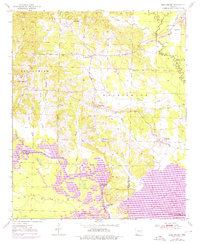
1950 Map of Ben Lomond
USGS Topo · Published 1966About this map
Ben Lomond and the surrounding timberlands of Sevier and Little River counties are documented here in 1950, showing a landscape defined by meandering river bottoms and small rural communities. The southern portion of the map is dominated by the winding course of the Little River, where numerous sloughs and oxbow lakes like Horseshoe Lake and McGuire Lake indicate an active floodplain. Cultural life at mid-century is centered around rural landmarks such as Rice Chapel, Gravelly Hill Ch, and Graves Sch, alongside the tiny settlements of Cowlingsville and Brownstown. The rail-and-river economy of the era is evident at the village of White Cliffs, where the Graysonia Nashville and Ashdown railroad line serves the White Cliffs Station near a prominent Gaging Station and Gravel Pit. Further east, the village of Paraloma sits near the Saline River junction, illustrating the distributed nature of post-war Arkansas river-valley settlement.
Find a feature on this map
46 named features on this map. Tap any name to fly to it.
Don’t see what you’re looking for? This feature index may not catch every label — zoom into the map to look around manually.
Map Details
Editions of this 1950 Ben Lomond Map
2 editions found
Other maps of this area

1950 · Ashdown East
USGS Topo · 1:24,000

1950 · Ashdown West
USGS Topo · 1:24,000

1950 · Red Bluff
USGS Topo · 1:24,000

1950 · Falls Chapel
USGS Topo · 1:24,000

1951 · Ben Lomond
USGS Topo · 1:24,000

1951 · Ashdown West
USGS Topo · 1:24,000

1951 · Red Bluff
USGS Topo · 1:24,000

1951 · Falls Chapel
USGS Topo · 1:24,000

1951 · Ashdown East
USGS Topo · 1:24,000

1951 · Mineral Springs South
USGS Topo · 1:24,000