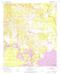
1950 Map of Ben Lomond
USGS Topo · Published 1976About this map
Ben Lomond and the surrounding Arkansas lowlands are defined by the winding course of the Little River, which snakes through the southern half of this mid-century survey. The landscape is a composite of rural settlements and industrial vestiges, notably the White Cliffs Station and the nearby White Cliffs School. By the mid-1970s, the emergence of Millwood Lake in the southeast corner fundamentally altered the local drainage, inundating previous terrain near the Saline River confluence. Genealogy and local history researchers will find a dense network of community centers, including Rice Chapel, Gravelly Hill Ch, and the Brownstown Cem. An Old Railroad grade and a modern pipeline trace the evolution of transit and infrastructure through the timber and agricultural lands of the Washington and Cleveland townships.
Find a feature on this map
40 named features on this map. Tap any name to fly to it.
Don’t see what you’re looking for? This feature index may not catch every label — zoom into the map to look around manually.
Map Details
Editions of this 1950 Ben Lomond Map
2 editions found
Other maps of this area

1950 · Ashdown East
USGS Topo · 1:24,000

1950 · Ashdown West
USGS Topo · 1:24,000

1950 · Red Bluff
USGS Topo · 1:24,000

1950 · Ben Lomond
USGS Topo · 1:24,000

1950 · Falls Chapel
USGS Topo · 1:24,000

1951 · Ben Lomond
USGS Topo · 1:24,000

1951 · Ashdown West
USGS Topo · 1:24,000

1951 · Red Bluff
USGS Topo · 1:24,000

1951 · Falls Chapel
USGS Topo · 1:24,000

1951 · Ashdown East
USGS Topo · 1:24,000