1960s Maps of Calion, Arkansas
Explore 3 historic maps of Calion from the 1960s. These maps offer a rare glimpse into what life looked like during the 1960s — showing old roads, neighborhoods, homes, and landmarks that have changed or disappeared over time.
Whether you're researching your family's past, planning a metal detecting trip, or studying how Calion's landscape evolved across the 1960s, these high-resolution maps are a powerful tool for exploring the history of this region.
- Focus on a specific era: All maps on this page are from the 1960s, giving you a focused view of this time period.
- See what’s changed: Compare century-old streets, trails, and buildings to today's modern landscape using overlays and satellite layers.
- Research with precision: Use these maps for genealogy, historical research, land use analysis, or educational projects.
- View, download, or print: Maps are fully viewable online in high resolution, and can be downloaded or printed for your own records.
Start exploring Calion's history through authentic maps from the 1960s. This is your window into the past.
Calion, AR maps
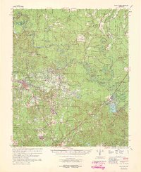
(3)- 1960 Map of El Dorado
 1960 El Dorado1960 Print · USGSSouth Central Arkansas in the late fifties was a hub of energy production and defense industry. Researchers can trace the extensive Oil and Gas Fields around El Dorado or locate family landmarks like Old Park Cem and New Hope Church.
 - 1962 Map of Calion, 1963 Print
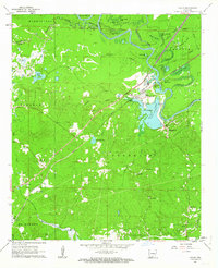 1962 Calion1963 Print · USGSUnion County during the early 1960s shows a landscape defined by the winding Ouachita River and a growing petroleum industry. Researchers can trace rural church history at Bethel Ch or explore the rail corridor of the Chicago Rock Island and Pacific.2 unique versions available
 - 1964 Map of Smackover
 1964 Smackover1964 Print · USGSSouthern Arkansas in the mid-sixties was a landscape defined by the booming petroleum industry and the winding path of the Ouachita River. Genealogists and historians can locate rural landmarks like St Paul Ch, Beech Springs Camp, and the busy Smackover Oil & Gas Field.2 unique versions available
End of results
Showing maps 1-3 of 3
Top cities near Calion
- El Dorado historical maps
- Smackover historical maps
- Hampton historical maps
- Norphlet historical maps
- Strong historical maps
- Harrell historical maps
Frequently asked questions
- What are the different types of historical maps available for Calion?
- What is the oldest map of Calion?
- Where can I purchase historical maps of Calion for my home or office?
- Where can I download high-res historical maps of Calion?
- Are there historical topographic maps available for Calion?
- Is there historical aerial imagery available for Calion?
- Where are historical maps of Calion sourced from?