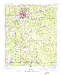
1960 Map of El Dorado
USGS Topo · Published 1960About this map
The Ouachita River and Saline River define the drainage of South Central Arkansas in this mid-century survey, which reveals a landscape deeply influenced by natural resources and defense infrastructure. Large concentrations of Oil and Gas Fields dominate the vicinity of El Dorado and Smackover, while the presence of the U S Naval Ammunition Depot north of Camden highlights the region's strategic importance. Moving west toward Magnolia and Hope, the map documents the transition into agricultural research areas like the University of Arkansas Experiment Station. Transportation networks are well-established, with the Missouri Pacific and St Louis Southwestern railroads connecting timber and industrial towns. Local history is preserved through markers for the Old Park Cem and Macedonia Church, providing fine-grain detail for genealogists tracing family roots across the Arkansas-Louisiana border.
Find a feature on this map
80 named features on this map. Tap any name to fly to it.
Don’t see what you’re looking for? This feature index may not catch every label — zoom into the map to look around manually.
Map Details
Editions of this 1960 El Dorado Map
This is the sole edition of this map. No revisions or reprints were ever made.
Historical Maps of Texarkana Through Time
9 maps found