1924 Map of Sarepta
USGS Topo · Published 1924About this map
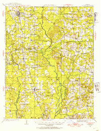
The Louisiana and Arkansas Railway corridor dictates the rhythm of growth across this portion of Webster and Bossier Parishes in the early 1920s. Centered on Sarepta, the map reveals a landscape defined by its waterways, including Doreheat Bayou and Cypress Bayou. These drainages separate the upland settlements from lower swampy areas like The Flats. Regional connectivity at the time relied on river crossings such as Sykes Ferry and Stroud Bridge, highlighting a period before modernized highway infrastructure. Social life is deeply localized, anchored by institutions like Old Shongaloo Church and Thomasville School. In the south, Cotton Valley and Couchwood mark established hubs, while the northwestern corner is distinguished by the large colonial-era Manuel Ogarte Grant, providing a contrast to the standard township and range surveying patterns found elsewhere on the sheet.
Find a feature on this map
94 named features on this map. Tap any name to fly to it.
Don’t see what you’re looking for? This feature index may not catch every label — zoom into the map to look around manually.
Map Details
Editions of this 1924 Sarepta Map
This is the sole edition of this map. No revisions or reprints were ever made.
Historical Maps of Springhill Through Time
3 maps found