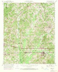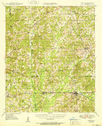
1950 Map of Gibsland
USGS Topo · Published 1950About this map
The Illinois Central railroad corridor anchors this mid-century landscape, linking the hubs of Gibsland and Ada. This survey details a dense network of rural community centers, particularly the numerous country churches and schools that served the dispersed population across Bienville, Claiborne, and Webster Parishes. The transition from older settlements like Old Athens to the then-active Athens Gas Field illustrates the shift from strictly agrarian life to the burgeoning energy economy of the late 1940s. Moving through the center of the map, Black Lake Bayou and Leatherman Creek define the low-lying terrain, while Rocky Ridge provides a prominent high point to the north. Genealogists will find significant value in the documentation of family-named landmarks and cemeteries, including Martin Cem, Miller Cem, and Germantown Cem, along with specialized rural sites like the Airway Beacon and the Athens Lookout Tower.
Find a feature on this map
102 named features on this map. Tap any name to fly to it.
Don’t see what you’re looking for? This feature index may not catch every label — zoom into the map to look around manually.
Map Details
Editions of this 1950 Gibsland Map
This is the sole edition of this map. No revisions or reprints were ever made.
Historical Maps of Minden Through Time
8 maps found