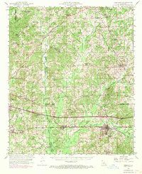
1949 Map of Gibsland
USGS Topo · Published 1969About this map
Gibsland serves as a central hub in this mid-century portrait of the north Louisiana hill country, where the intersection of the Illinois Central and the Louisiana and North West railroads anchor the local economy. The landscape is characterized by a dense network of family-named landmarks and rural institutions, from the Athens Lookout Tower to the many country churches like Holly Springs Ch and Mt Paren Ch.
Find a feature on this map
71 named features on this map. Tap any name to fly to it.
Don’t see what you’re looking for? This feature index may not catch every label — zoom into the map to look around manually.
Map Details
Editions of this 1949 Gibsland Map
2 editions found
Other maps of this area

1922 · Sarepta
USGS Topo · 1:62,500

1924 · Sarepta
USGS Topo · 1:62,500

1947 · Ringgold
USGS Topo · 1:62,500

1947 · Bienville
USGS Topo · 1:62,500

1947 · Minden
USGS Topo · 1:62,500

1948 · Jamestown
USGS Topo · 1:62,500

1949 · Jamestown
USGS Topo · 1:62,500

1949 · Bienville
USGS Topo · 1:62,500

1949 · Minden
USGS Topo · 1:62,500

1949 · Gibsland
USGS Topo · 1:62,500