1930s Maps of Payne, Arkansas
Explore 3 historic maps of Payne from the 1930s. These maps offer a rare glimpse into what life looked like during the 1930s — showing old roads, neighborhoods, homes, and landmarks that have changed or disappeared over time.
Whether you're researching your family's past, planning a metal detecting trip, or studying how Payne's landscape evolved across the 1930s, these high-resolution maps are a powerful tool for exploring the history of this region.
- Focus on a specific era: All maps on this page are from the 1930s, giving you a focused view of this time period.
- See what’s changed: Compare century-old streets, trails, and buildings to today's modern landscape using overlays and satellite layers.
- Research with precision: Use these maps for genealogy, historical research, land use analysis, or educational projects.
- View, download, or print: Maps are fully viewable online in high resolution, and can be downloaded or printed for your own records.
Start exploring Payne's history through authentic maps from the 1930s. This is your window into the past.
Payne, AR maps
(3)- 1933 Map of Strong, 1954 Print
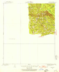 1933 Strong1954 Print · USGSUnion County, Arkansas, was a landscape of bayous and timber mills during the early 1930s. Genealogists and local historians can trace the rural fabric of the region through landmarks like George Cem, New London, and the Mcclendon Mill.
 - 1937 Map of Strong
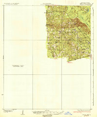 1937 Strong1937 Print · USGSUnion County and the bayou country of southern Arkansas are captured here during the 1930s. Genealogists and local historians can trace rural roots through landmarks like Wallace Cem, McClendon Mill, and Ebenezer Ch.2 unique versions available
 - 1939 Map of Strong, 1948 Print
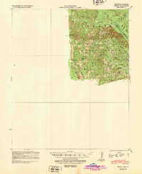 1939 Strong1948 Print · USGSUnion County, Arkansas, comes to life in the 1930s as a land of small timber settlements and rural parishes. Researchers can trace family roots through sites like Ebenezer Cem, McGlendon Mill, and the many schools including Gill Sch.
End of results
Showing maps 1-3 of 3
Top cities near Payne
- El Dorado historical maps
- Norphlet historical maps
- Strong historical maps
- Calion historical maps
- Spearsville historical maps
- Lillie historical maps
Frequently asked questions
- What are the different types of historical maps available for Payne?
- What is the oldest map of Payne?
- Where can I purchase historical maps of Payne for my home or office?
- Where can I download high-res historical maps of Payne?
- Are there historical topographic maps available for Payne?
- Is there historical aerial imagery available for Payne?
- Where are historical maps of Payne sourced from?