1990s Maps of Oakland, California
Explore 9 historic maps of Oakland from the 1990s. These maps offer a rare glimpse into what life looked like during the 1990s — showing old roads, neighborhoods, homes, and landmarks that have changed or disappeared over time.
Whether you're researching your family's past, planning a metal detecting trip, or studying how Oakland's landscape evolved across the 1990s, these high-resolution maps are a powerful tool for exploring the history of this region.
- Focus on a specific era: All maps on this page are from the 1990s, giving you a focused view of this time period.
- See what’s changed: Compare century-old streets, trails, and buildings to today's modern landscape using overlays and satellite layers.
- Research with precision: Use these maps for genealogy, historical research, land use analysis, or educational projects.
- View, download, or print: Maps are fully viewable online in high resolution, and can be downloaded or printed for your own records.
Start exploring Oakland's history through authentic maps from the 1990s. This is your window into the past.
Oakland, CA maps
(9)- 1993 Map of Oakland West, 1997 Print
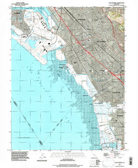
 1993 Oakland West1997 Print · USGSThe East Bay waterfront in the early nineties is defined by its massive military bases and the double-decked span of the Bay Bridge. Trace the expansive layouts of the Alameda Naval Air Station and Oakland Army Base alongside local landmarks like Jack London Square.
 - 1993 Map of Las Trampas Ridge, 1997 Print
 1993 Las Trampas Ridge1997 Print · USGSContra Costa and Alameda counties show a mix of dense suburban development and protected ridges in the 1990s. Trace the expansion of Lafayette and Moraga or locate landmarks like St Marys College and Upper San Leandro Reservoir.
 - 1993 Map of San Leandro, 1997 Print
 1993 San Leandro1997 Print · USGSThe East Bay shoreline comes alive in the early nineties, showcasing the expansion of Oakland and San Leandro. Trace the legacy of coastal industry through Salt Evaporators and historical sites like Roberts Landing and Russell City.
 - 1993 Map of Hayward, 1997 Print
 1993 Hayward1997 Print · USGSHayward and the East Bay hills are documented here in the 1990s as the suburban and academic landscape fully matured. Genealogists can trace family sites at Holy Sepulchre Cemetery or Mt Eden Cemetery, while local historians can locate the old Mt Eden Station.
 - 1993 Map of Hunters Point, 1997 Print
 1993 Hunters Point1997 Print · USGSSan Francisco and the East Bay shoreline appear here in the early nineties, showing a landscape of naval history and maritime industry. Trace the piers at Hunters Point, the U.S. Naval Reservation, and dredging at Oyster Point Channel.
 - 1993 Map of Briones Valley, 1997 Print
 1993 Briones Valley1997 Print · USGSContra Costa County in the early nineties reveals a landscape of high ridges and critical water infrastructure between expanding suburban centers. Trace the historical borders of the John Muir National Historic Site and the rugged peaks surrounding Briones Reservoir and Orinda Village.
 - 1995 Map of Briones Valley, 1999 Print
 1995 Briones Valley1999 Print · USGSContra Costa County in the 1990s shows a landscape of protected ridges and expanding valley settlements. Local historians can trace family land across Rancho El Sobrante or locate landmarks like the John Muir National Historic Site and Orinda Village.
 - 1995 Map of Las Trampas Ridge, 1999 Print
 1995 Las Trampas Ridge1999 Print · USGSContra Costa County at the end of the century shows a unique balance between the developing San Ramon Valley and the protected heights of Las Trampas Ridge. Genealogists and hikers can trace the geography around St Marys College, Brown Ranch, and the Oakland Zoo in Knowland Park.
 - 1997 Map of Oakland East
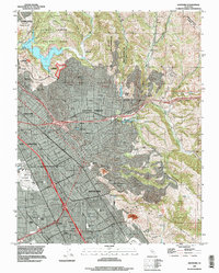
 1997 Oakland East1997 Print · USGSThe East Bay waterfront and hills are captured here in the late 1990s as the urban corridor meets the ridge. Trace historic sites like Mountain View Cemetery, the University of California, and the Coast Guard Alameda Base.
End of results
Showing maps 1-9 of 9
Top cities near Oakland
- San Francisco historical maps
- Fremont historical maps
- Hayward historical maps
- Concord historical maps
- Berkeley historical maps
- Richmond historical maps
See more
Top neighborhoods of Oakland
- East Oakland historical maps
- West Oakland historical maps
- Oakland Hills historical maps
- Downtown Oakland historical maps
- North Oakland historical maps
- Financial District historical maps
See more
Frequently asked questions
- What are the different types of historical maps available for Oakland?
- What is the oldest map of Oakland?
- Where can I purchase historical maps of Oakland for my home or office?
- Where can I download high-res historical maps of Oakland?
- Are there historical topographic maps available for Oakland?
- Is there historical aerial imagery available for Oakland?
- Where are historical maps of Oakland sourced from?