1800s (19th Century) Maps of Cresta, California
Explore 5 historic maps of Cresta from the 1800s (19th Century). These maps offer a rare glimpse into what life looked like during the 1800s — showing old roads, neighborhoods, homes, and landmarks that have changed or disappeared over time.
Whether you're researching your family's past, planning a metal detecting trip, or studying how Cresta's landscape evolved across the 1800s, these high-resolution maps are a powerful tool for exploring the history of this region.
- Focus on a specific era: All maps on this page are from the 1800s, giving you a focused view of this time period.
- See what’s changed: Compare century-old streets, trails, and buildings to today's modern landscape using overlays and satellite layers.
- Research with precision: Use these maps for genealogy, historical research, land use analysis, or educational projects.
- View, download, or print: Maps are fully viewable online in high resolution, and can be downloaded or printed for your own records.
Start exploring Cresta's history through authentic maps from the 1800s. This is your window into the past.
Cresta, CA maps
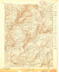
(5)- 1888 Map of Bidwell Bar, 1956 Print
 1888 Bidwell Bar1956 Print · USGSThe northern Sierra foothills and Feather River canyons come alive in the late nineteenth century before modern reservoirs altered the landscape. Genealogists and researchers can trace family-named sites like Fields Ranch, Spanish Ranch, and Snows Mine.
 - 1891 Map of Bidwell Bar
 1891 Bidwell Bar1891 Print · USGSThe gold-country ridges and deep river canyons of the northern Sierras are shown in the late nineteenth century as mining and timber production shaped the land. Researchers can trace early family-named waystations and industrial sites like American House, Bidwell Bar, and Clipper Mill.
 - 1893 Map of Bidwell Bar
 1893 Bidwell Bar1893 Print · USGSThe Plumas mountains during the late nineteenth century show a landscape defined by gold-era mining and remote stage stops. Genealogists and historians can locate early homesteads and industrial sites like Snows Mine, American House, and Bidwell Bar.
 - 1895 Map of Bidwell Bar
 1895 Bidwell Bar1895 Print · USGSThe Sierra foothills and high ridges of Northern California are captured here in the late nineteenth century. Genealogists and historians can trace isolated waystations and timber camps like American House, Spanish Ranch, and the Old Defiance Mill.
 - 1897 Map of Bidwell Bar
 1897 Bidwell Bar1897 Print · USGSThe Sierra Nevada foothills and river canyons come alive in the 1890s as a landscape of remote mines and mountain ranching. Genealogists can trace early homesteads and social hubs like Spanish Ranch, Forbestown, and Old Defiance Mill.7 unique versions available
End of results
Showing maps 1-5 of 5
Top cities near Cresta
Frequently asked questions
- What are the different types of historical maps available for Cresta?
- What is the oldest map of Cresta?
- Where can I purchase historical maps of Cresta for my home or office?
- Where can I download high-res historical maps of Cresta?
- Are there historical topographic maps available for Cresta?
- Is there historical aerial imagery available for Cresta?
- Where are historical maps of Cresta sourced from?