1950s Maps of Nord, California
Explore 3 historic maps of Nord from the 1950s. These maps offer a rare glimpse into what life looked like during the 1950s — showing old roads, neighborhoods, homes, and landmarks that have changed or disappeared over time.
Whether you're researching your family's past, planning a metal detecting trip, or studying how Nord's landscape evolved across the 1950s, these high-resolution maps are a powerful tool for exploring the history of this region.
- Focus on a specific era: All maps on this page are from the 1950s, giving you a focused view of this time period.
- See what’s changed: Compare century-old streets, trails, and buildings to today's modern landscape using overlays and satellite layers.
- Research with precision: Use these maps for genealogy, historical research, land use analysis, or educational projects.
- View, download, or print: Maps are fully viewable online in high resolution, and can be downloaded or printed for your own records.
Start exploring Nord's history through authentic maps from the 1950s. This is your window into the past.
Nord, CA maps
(3)- 1951 Map of Nord, 1952 Print
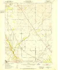 1951 Nord1952 Print · USGSNorthern Butte County thrived as an orchard and rail corridor during the mid-century, before modernization shifted the rural landscape. Researchers can locate the Shasta Union Sch, trace the Southern Pacific tracks, or find family plots at the Pine Creek Cem.4 unique versions available
 - 1952 Map of Richardson Springs, 1959 Print
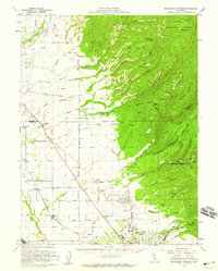 1952 Richardson Springs1959 Print · USGSNorth of Chico in the early 1950s, the landscape shifts from the flat valley floor near Nord to the steep canyons of the Lassen National Forest. You can trace family ranching history at Stephens Ranch, locate the Old Spanish Corral, or find the secluded Richardson Springs resort area.2 unique versions available
 - 1958 Map of Chico, 1962 Print
 1958 Chico1962 Print · USGSMid-century Northern California comes to life across the Central Valley and high Sierras as the postwar economy transformed the landscape. Trace the rail lines of the Southern Pacific RR, locate family roots near Chico Cem, or explore the early layout of Paradise and Beale Air Force Base.4 unique versions available
End of results
Showing maps 1-3 of 3
Top cities near Nord
- Chico historical maps
- Corning historical maps
- Durham historical maps
- Los Molinos historical maps
- Vina historical maps
Frequently asked questions
- What are the different types of historical maps available for Nord?
- What is the oldest map of Nord?
- Where can I purchase historical maps of Nord for my home or office?
- Where can I download high-res historical maps of Nord?
- Are there historical topographic maps available for Nord?
- Is there historical aerial imagery available for Nord?
- Where are historical maps of Nord sourced from?