1960s Maps of Mountain Ranch Subdivision, California
Explore 2 historic maps of Mountain Ranch Subdivision from the 1960s. These maps offer a rare glimpse into what life looked like during the 1960s — showing old roads, neighborhoods, homes, and landmarks that have changed or disappeared over time.
Whether you're researching your family's past, planning a metal detecting trip, or studying how Mountain Ranch Subdivision's landscape evolved across the 1960s, these high-resolution maps are a powerful tool for exploring the history of this region.
- Focus on a specific era: All maps on this page are from the 1960s, giving you a focused view of this time period.
- See what’s changed: Compare century-old streets, trails, and buildings to today's modern landscape using overlays and satellite layers.
- Research with precision: Use these maps for genealogy, historical research, land use analysis, or educational projects.
- View, download, or print: Maps are fully viewable online in high resolution, and can be downloaded or printed for your own records.
Start exploring Mountain Ranch Subdivision's history through authentic maps from the 1960s. This is your window into the past.
Mountain Ranch Subdivision, CA maps
(2)- 1962 Map of San Andreas, 1963 Print
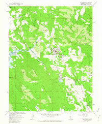 1962 San Andreas1963 Print · USGSSan Andreas and the surrounding Calaveras County hills are shown here in the early 1960s, documenting a landscape shaped by mining and industrial growth. Researchers can trace the SOUTHERN PACIFIC line through Kentucky House, locate family-named sites like the Cassinelli Mine, and find the Pioneer Cem.3 unique versions available
 - 1962 Map of San Andreas, 1964 Print
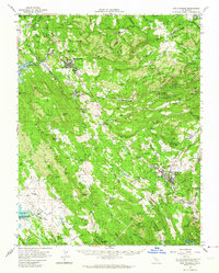 1962 San Andreas1964 Print · USGSCalaveras County is captured here in the early 1960s, a landscape defined by its Gold Country heritage and evolving water infrastructure. Genealogists and historians can trace the legacy of mining and early settlement through sites like Angels Camp, the Pioneer Cemetery, and the Cave City Mine.2 unique versions available
End of results
Showing maps 1-2 of 2
Top cities near Mountain Ranch Subdivision
Frequently asked questions
- What are the different types of historical maps available for Mountain Ranch Subdivision?
- What is the oldest map of Mountain Ranch Subdivision?
- Where can I purchase historical maps of Mountain Ranch Subdivision for my home or office?
- Where can I download high-res historical maps of Mountain Ranch Subdivision?
- Are there historical topographic maps available for Mountain Ranch Subdivision?
- Is there historical aerial imagery available for Mountain Ranch Subdivision?
- Where are historical maps of Mountain Ranch Subdivision sourced from?