1940s Maps of City and County of San Francisco, California
Explore 11 historic maps of City and County of San Francisco from the 1940s. These maps offer a rare glimpse into what life looked like during the 1940s — showing old roads, neighborhoods, homes, and landmarks that have changed or disappeared over time.
Whether you're researching your family's past, planning a metal detecting trip, or studying how City and County of San Francisco's landscape evolved across the 1940s, these high-resolution maps are a powerful tool for exploring the history of this region.
- Focus on a specific era: All maps on this page are from the 1940s, giving you a focused view of this time period.
- See what’s changed: Compare century-old streets, trails, and buildings to today's modern landscape using overlays and satellite layers.
- Research with precision: Use these maps for genealogy, historical research, land use analysis, or educational projects.
- View, download, or print: Maps are fully viewable online in high resolution, and can be downloaded or printed for your own records.
Start exploring City and County of San Francisco's history through authentic maps from the 1940s. This is your window into the past.
City and County of San Francisco, CA maps
(11)- 1941 Map of Tamalpais
 1941 Tamalpais1941 Print · USGSMarin County's coastal defenses and rail-connected towns are captured here just as the nation entered World War II. Researchers can trace the early fortifications at Fort Cronkhite, the path of the Northwestern Pacific RR, and old landmarks like Bolinas School.
 - 1943 Map of San Mateo
 1943 San Mateo1943 Print · USGSThe San Francisco Peninsula during the mid-war years shows a region of expanding shoreline industry and established hillside communities. Researchers can trace historic landmarks like St Josephs Military Academy and the Golden Gate National Cem.
 - 1947 Map of San Francisco, 1948 Print
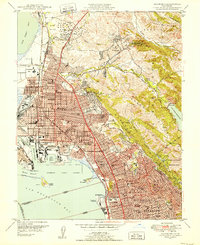
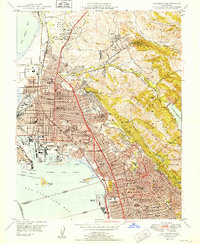
 1947 San Francisco1948 Print · USGSThe Bay Area in the late 1940s reveals a region transitioning from wartime intensity to post-war suburban growth. Trace the historic rail lines of the Southern Pacific RR or locate early military footprints at Fort Funston and Moffett Field.
 - 1947 Map of Richmond, 1952 Print
 1947 Richmond1952 Print · USGSPost-war development transforms the East Bay shoreline as industry and suburbs expand between the bay and the hills. Trace mid-century landmarks like the Oil Tank Farm, Richmond Union HS, and the sprawling Charles Lee Tilden Regional Park.2 unique versions available
 - 1947 Map of San Francisco South, 1955 Print
 1947 San Francisco South1955 Print · USGSPost-war San Mateo County and the city's southern edge are caught here during a period of rapid peninsula growth. Genealogists can trace the many memorial grounds of Colma, while historians can locate the Tanforan Race Track and early San Francisco International Airport.
 - 1947 Map of San Francisco North, 1955 Print
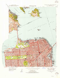 1947 San Francisco North1955 Print · USGSSan Francisco and the Marin coastline are captured here in the years following World War II, just as the city's modern skyline began to take shape. Researchers can trace historic landmarks like Mission Dolores, early waterfront infrastructure at Mission Rock, and the military outposts of Fort Baker Military Reservation.
 - 1947 Map of San Quentin, 1956 Print
 1947 San Quentin1956 Print · USGSThe San Francisco Bay area in the late 1940s reveals a landscape of ferry-connected shores and burgeoning industry. Trace the historic Richmond-San Rafael Ferry route, the State Penitentiary, and the Tiburon Naval Net Depot.
 - 1948 Map of San Quentin
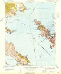 1948 San Quentin1948 Print · USGSThe North Bay waterfront comes alive in the late 1940s, showing the active ferry routes and military installations of the era. Genealogists and historians can trace the Richmond-San Rafael Ferry, the State Penitentiary, and the Tiburon Naval Net Depot.2 unique versions available
 - 1948 Map of San Francisco, 1951 Print
 1948 San Francisco1951 Print · USGSThe Bay Area in the late 1940s reveals a landscape defined by rapid post-war growth and a heavy military presence at the Golden Gate. Trace the development of early trans-bay infrastructure like the Oakland-Bay Bridge and historic coastal defense sites such as Fort Funston and Alcatraz Island.
 - 1949 Map of Oakland West
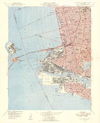 1949 Oakland West1949 Print · USGSThe East Bay waterfront was a bustling landscape of rail yards and military installations in the late 1940s. Genealogists and historians can trace the neighborhood schools and piers of Berkeley and Oakland, from the Oakland Mole to Notre Dame Academy.2 unique versions available
 - 1949 Map of Richmond
 1949 Richmond1949 Print · USGSThe East Bay shoreline in the late forties shows a booming industrial and residential corridor shaped by the Southern Pacific rail lines. Researchers can trace mid-century neighborhood growth and find local landmarks like the Oil Tank Farm, St Joseph Cem, and Stege.2 unique versions available
End of results
Showing maps 1-11 of 11
Top cities of City and County of San Francisco
Frequently asked questions
- What are the different types of historical maps available for City and County of San Francisco?
- What is the oldest map of City and County of San Francisco?
- Where can I purchase historical maps of City and County of San Francisco for my home or office?
- Where can I download high-res historical maps of City and County of San Francisco?
- Are there historical topographic maps available for City and County of San Francisco?
- Is there historical aerial imagery available for City and County of San Francisco?
- Where are historical maps of City and County of San Francisco sourced from?