1950s Maps of Harrington, California
Explore 3 historic maps of Harrington from the 1950s. These maps offer a rare glimpse into what life looked like during the 1950s — showing old roads, neighborhoods, homes, and landmarks that have changed or disappeared over time.
Whether you're researching your family's past, planning a metal detecting trip, or studying how Harrington's landscape evolved across the 1950s, these high-resolution maps are a powerful tool for exploring the history of this region.
- Focus on a specific era: All maps on this page are from the 1950s, giving you a focused view of this time period.
- See what’s changed: Compare century-old streets, trails, and buildings to today's modern landscape using overlays and satellite layers.
- Research with precision: Use these maps for genealogy, historical research, land use analysis, or educational projects.
- View, download, or print: Maps are fully viewable online in high resolution, and can be downloaded or printed for your own records.
Start exploring Harrington's history through authentic maps from the 1950s. This is your window into the past.
Harrington, CA maps
(3)- 1958 Map of Santa Rosa, 1968 Print
 1958 Santa Rosa1968 Print · USGSThe North Bay and Wine Country are captured in the mid-twentieth century as the region balanced its agricultural roots with a growing military and recreational footprint. Researchers can trace the Northwestern Pacific RR through the Russian River valley or locate landmarks like the Petaluma Adobe Historical Monument and The Geysers Resort.3 unique versions available
 - 1959 Map of Wildwood School, 1961 Print
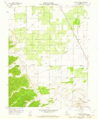 1959 Wildwood School1961 Print · USGSThe rural border of Colusa and Yolo counties is captured here in the late fifties, showcasing a landscape of structured farmland and rising hills. Genealogists and local historians can trace the Wildwood School and the rail stop at Harrington along the Southern Pacific tracks.3 unique versions available
 - 1959 Map of Guinda, 1962 Print
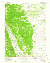 1959 Guinda1962 Print · USGSThe Capay Valley was a vital agricultural and transport corridor in the late 1950s, centered on the flow of Cache Creek. Researchers can trace the Southern Pacific rail line and discover local landmarks like the Rumsey Rancheria, Wildwood Sch, and Tancred.2 unique versions available
End of results
Showing maps 1-3 of 3
Top cities near Harrington
Frequently asked questions
- What are the different types of historical maps available for Harrington?
- What is the oldest map of Harrington?
- Where can I purchase historical maps of Harrington for my home or office?
- Where can I download high-res historical maps of Harrington?
- Are there historical topographic maps available for Harrington?
- Is there historical aerial imagery available for Harrington?
- Where are historical maps of Harrington sourced from?