Old Maps of Leesville, California for Academic Research
Study the evolution of Leesville with 11 high-resolution historic maps. Whether you're teaching, researching, or modeling changes in land use, these maps provide essential visual documentation of urban, environmental, and geographic change.
- Analyze long-term change: Track patterns in development, transportation, and natural features.
- Ideal for environmental or urban studies: Support academic projects with primary historical map data.
- Use in the classroom or lab: Educators and researchers rely on these maps to bring historical context to life.
These maps are a powerful tool for teaching, research, and visualizing how Leesville has changed over the decades.
Leesville, CA maps
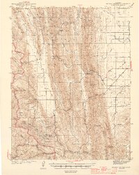
(11)- 1920 Map of Venado
 1920 Venado1920 Print · USGSColusa County mineral springs and mountain passes are captured here during the years following the Great War. Researchers can trace the path of the Colusa & Lake R.R. (Abandoned) and locate historic mining sites like the Abbott Mercury Mine and Wilbur Springs.
 - 1944 Map of Wilbur Springs
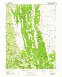
 1944 Wilbur Springs1944 Print · USGSNorthern California mining country comes to life in this mid-forties survey of the Coast Ranges. Researchers can trace the quicksilver industry through sites like Abbott Mine and locate rural family history at Leesville or the Huffmaster Ranch.3 unique versions available
 - 1957 Map of Ukiah, 1966 Print
 1957 Ukiah1966 Print · USGSNorthern California's diverse terrain comes into focus in the mid-1950s, from the rugged timberlands of the Jackson State Forest to the productive Sacramento Valley. Genealogists and historians can trace the rail lines of the Northwestern Pacific or locate early valley settlements like Arbuckle and Paskenta.3 unique versions available
 - 1960 Map of Ukiah
 1960 Ukiah1960 Print · USGSNorthern California during the late fifties reveals a landscape of deep timber forests and valley agriculture before modern expansion. Trace the historic rail lines of the California Western RR and the Northwestern Pacific RR through settlements like Fort Bragg and Ukiah.2 unique versions available
 - 1961 Map of Wilbur Springs, 1963 Print
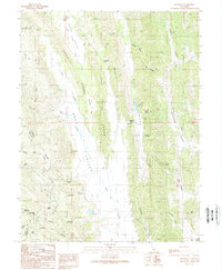
 1961 Wilbur Springs1963 Print · USGSThe mining districts and remote ranchlands of Colusa and Lake Counties are documented here in the early sixties. Genealogists and industrial historians can trace the operations of the Abbott Mine and Clyde Mine, or locate vanished communities like Leesville and Skinnerville.2 unique versions available
 - 1989 Map of Leesville
 1989 Leesville1989 Print · USGSThe ranching and valley corridors of the California Coast Range are captured here in the late eighties. Researchers can trace remote routes through Leesville, locate the historic Robbers Flat, and find family-named landmarks like Stinchfield Canyon and Gaither.2 unique versions available
 - 1994 Map of Lakeport
 1994 Lakeport1994 Print · USGSCoastal mountains meet the fertile Sacramento Valley in the 1990s, where the waters of Clear Lake define the western landscape. Researchers can trace the industrial footprint of the Sulphur Bank Mine, follow the Southern Pacific RR tracks, or locate old settlements like Fouts Springs and Lodoga.
 - 2012 Map of Leesville, 2012 Print
 2012 Leesville2012 Print · USGSCovers Leesville, including Lake County, Colusa County, and other nearby areas
 - 2015 Map of Leesville, 2015 Print
 2015 Leesville2015 Print · USGSCovers Leesville, including Lake County, Colusa County, and other nearby areas
 - 2018 Map of Leesville, 2018 Print
 2018 Leesville2018 Print · USGSCovers Leesville, including Lake County, Colusa County, and other nearby areas
 - 2022 Map of Leesville, 2022 Print
 2022 Leesville2022 Print · USGSLeesville and the surrounding high valleys of Colusa and Lake Counties are documented here in detail during the early 2020s. Genealogists and local historians can trace the paths of the Old Leesville Grade and locate family landmarks like the Leesville Cem and Robbers Flat.
End of results
Showing maps 1-11 of 11
Top cities near Leesville
Frequently asked questions
- What are the different types of historical maps available for Leesville?
- What is the oldest map of Leesville?
- Where can I purchase historical maps of Leesville for my home or office?
- Where can I download high-res historical maps of Leesville?
- Are there historical topographic maps available for Leesville?
- Is there historical aerial imagery available for Leesville?
- Where are historical maps of Leesville sourced from?