1900-1909 Maps of Bay Point, California
Explore 2 historic maps of Bay Point from 1900-1909. These maps offer a rare glimpse into what life looked like during the 1900s — showing old roads, neighborhoods, homes, and landmarks that have changed or disappeared over time.
Whether you're researching your family's past, planning a metal detecting trip, or studying how Bay Point's landscape evolved across the 1900s, these high-resolution maps are a powerful tool for exploring the history of this region.
- Focus on a specific era: All maps on this page are from the 1900s, giving you a focused view of this time period.
- See what’s changed: Compare century-old streets, trails, and buildings to today's modern landscape using overlays and satellite layers.
- Research with precision: Use these maps for genealogy, historical research, land use analysis, or educational projects.
- View, download, or print: Maps are fully viewable online in high resolution, and can be downloaded or printed for your own records.
Start exploring Bay Point's history through authentic maps from the 1900s. This is your window into the past.
Bay Point, CA maps
(2)- 1907 Map of Antioch, 1955 Print
 1907 Antioch1955 Print · USGSThe Suisun Bay and Sacramento Delta regions are captured here in the early twentieth century during a period of agricultural and industrial expansion. Local historians can trace family-named river ports like Lingos Landing and rural landmarks such as Scandia School or the settlement of Birds Landing.
 - 1908 Map of Antioch
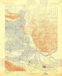 1908 Antioch1908 Print · USGSThe convergence of the great California rivers in the early twentieth century shows a landscape of busy water landings and growing rail towns. Trace the industrial roots of Antioch or locate vanished landings like Palmetto Landing and Duttons Landing along the sloughs.5 unique versions available
End of results
Showing maps 1-2 of 2
Top cities near Bay Point
- Oakland historical maps
- Concord historical maps
- Vallejo historical maps
- Fairfield historical maps
- Antioch historical maps
- Pittsburg historical maps
See more
Frequently asked questions
- What are the different types of historical maps available for Bay Point?
- What is the oldest map of Bay Point?
- Where can I purchase historical maps of Bay Point for my home or office?
- Where can I download high-res historical maps of Bay Point?
- Are there historical topographic maps available for Bay Point?
- Is there historical aerial imagery available for Bay Point?
- Where are historical maps of Bay Point sourced from?