
Loading...
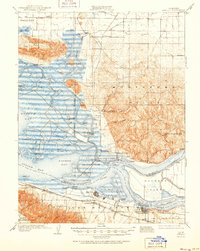
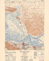
Loading map...1907 Map of Antioch
USGS Topo · Published 1955About this map
Suisun Bay and the confluence of the Sacramento River and San Joaquin River form a complex maritime landscape of marshy islands and tidal sloughs at the start of the twentieth century. The map illustrates a transitional economy where established river landings like Lingos Landing and Duttons Landing served the agricultural needs of the Montezuma Hills and the delta islands, even as industrial centers like Pittsburg and Antioch expanded along the southern shore.
Find a feature on this map
74 named features on this map. Tap any name to fly to it.
Don’t see what you’re looking for? This feature index may not catch every label — zoom into the map to look around manually.
Map Details
Date Portrayed1907
Date Published1955
PublisherU.S. Geological Survey
Map TypeTopographic
Scale1:62,500
Physical Dimensions16.6 x 20.8 inches
Editions of this 1907 Antioch Map
This is the sole edition of this map. No revisions or reprints were ever made.
Historical Maps of Concord Through Time
3 maps found
Featured Locations
Source Details
SourceU.S. Geological Survey
CopyrightPublic Domain