
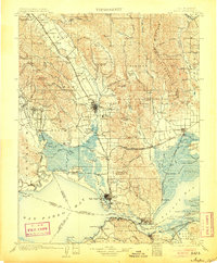
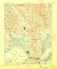
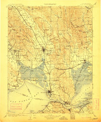
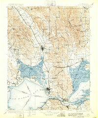
1902 Map of Napa
USGS Topo · Published 1902About this map
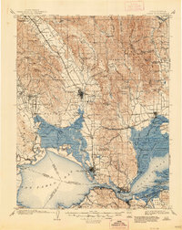
The Mare Island Navy Yard and the U. S. Arsenal at Benicia anchor the southern reaches of this 1902 survey, where the Carquinez Strait connects the San Pablo and Suisun Bays. This maritime and military hub is contrasted by the burgeoning viticultural and agricultural landscapes of the Napa Valley to the north. Rail lines including the Southern Pacific RR (Calistoga Branch) tie together settlements like St. Helena, Rutherford, and Oakville, following the course of the Napa River. Significant early institutions are documented here, notably the Insane Asylum south of Napa and the Veterans Home near Yountville. The map also captures the complex hydrology of the region, from the tidal marshes around Grizzly Island and Joice Island to the mineral springs at Napa Soda Springs, providing a comprehensive look at the industrial and social infrastructure of the North Bay at the turn of the century.
Find a feature on this map
183 named features on this map. Tap any name to fly to it.
Don’t see what you’re looking for? This feature index may not catch every label — zoom into the map to look around manually.
Map Details
Editions of this 1902 Napa Map
6 editions found
Other maps of this area

1895 · San Francisco
USGS Topo · 1:62,500

1896 · Carquinez Strait
USGS Topo · 1:62,500

1896 · Mt. Diablo
USGS Topo · 1:62,500

1897 · Concord
USGS Topo · 1:62,500

1897 · Tamalpais
USGS Topo · 1:62,500

1898 · Karquines
USGS Topo · 1:62,500

1898 · Mt. Diablo
USGS Topo · 1:62,500

1899 · San Francisco
USGS Topo · 1:62,500

1901 · Karquines
USGS Topo · 1:62,500
1907 · Woodland
USGS Topo · 1:62,500