
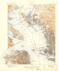
1895 Map of San Francisco
USGS Topo · Published 1895About this map
Dense urban blocks and developing infrastructure characterize the Alameda and San Francisco shorelines in this mid-1890s survey. The landscape is defined by its deep maritime and military connections, with the Presidio Military Reservation and Fort Mason guarding the south side of the Golden Gate. Across the bay, the massive rail infrastructure of the Oakland Mole extends into the water, serving as a primary transit hub for the Southern Pacific R. R. and the S. P. R. R. Livermore Line.
Find a feature on this map
121 named features on this map. Tap any name to fly to it.
Don’t see what you’re looking for? This feature index may not catch every label — zoom into the map to look around manually.
Map Details
Editions of this 1895 San Francisco Map
This is the sole edition of this map. No revisions or reprints were ever made.
Historical Maps of San Francisco Through Time
14 maps found
1895 San Francisco
San Francisco County, CA

1899 San Francisco
San Francisco County, CA
1915 San Francisco
San Francisco County, CA

1947 San Francisco
San Francisco County, CA

1948 San Francisco
San Francisco County, CA

1955 San Francisco
San Francisco County, CA
1956 San Francisco
San Francisco County, CA

1957 San Francisco
San Francisco County, CA

1960 San Francisco
San Francisco County, CA

1961 San Francisco
San Francisco County, CA

1964 San Francisco
San Francisco County, CA

1971 San Francisco
San Francisco County, CA

1978 San Francisco
San Francisco County, CA

1985 San Francisco
San Francisco County, CA