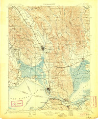
1902 Map of Napa
USGS Topo · Published 1905About this map
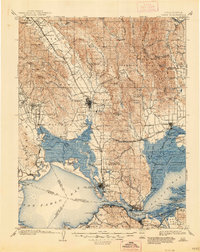
Vineyard names like Zinfandel and St. Helena already define the upper valley in this late nineteenth-century landscape, while the lower reaches focus on heavy maritime and institutional infrastructure. The Mare Island Navy Yard stands prominently at the entrance to the Carquinez Strait, anchoring a waterfront that includes the industrial nodes of South Vallejo, Benicia, and Port Costa. To the north, the agricultural and social fabric of the region is evident in the Veterans Home near Yountville and the Insane Asylum south of Napa.
Find a feature on this map
160 named features on this map. Tap any name to fly to it.
Don’t see what you’re looking for? This feature index may not catch every label — zoom into the map to look around manually.
Map Details
Editions of this 1902 Napa Map
6 editions found
Other maps of this area

1895 · San Francisco
USGS Topo · 1:62,500

1896 · Carquinez Strait
USGS Topo · 1:62,500

1896 · Mt. Diablo
USGS Topo · 1:62,500

1897 · Concord
USGS Topo · 1:62,500

1897 · Tamalpais
USGS Topo · 1:62,500

1898 · Karquines
USGS Topo · 1:62,500

1898 · Mt. Diablo
USGS Topo · 1:62,500

1899 · San Francisco
USGS Topo · 1:62,500

1901 · Karquines
USGS Topo · 1:62,500

1902 · Napa
USGS Topo · 1:125,000