1950s Maps of Danville, California
Explore 7 historic maps of Danville from the 1950s. These maps offer a rare glimpse into what life looked like during the 1950s — showing old roads, neighborhoods, homes, and landmarks that have changed or disappeared over time.
Whether you're researching your family's past, planning a metal detecting trip, or studying how Danville's landscape evolved across the 1950s, these high-resolution maps are a powerful tool for exploring the history of this region.
- Focus on a specific era: All maps on this page are from the 1950s, giving you a focused view of this time period.
- See what’s changed: Compare century-old streets, trails, and buildings to today's modern landscape using overlays and satellite layers.
- Research with precision: Use these maps for genealogy, historical research, land use analysis, or educational projects.
- View, download, or print: Maps are fully viewable online in high resolution, and can be downloaded or printed for your own records.
Start exploring Danville's history through authentic maps from the 1950s. This is your window into the past.
Danville, CA maps
(7)- 1953 Map of Diablo, 1954 Print
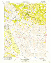 1953 Diablo1954 Print · USGSThe East Bay's inland valleys and foothills are captured here in the early fifties, just as the ranching era met suburban growth. Genealogists and local historians can locate early landmarks like Green Valley School, the San Ramon Siding, and the expansive Black Hawk Ranch.9 unique versions available
 - 1955 Map of San Francisco
 1955 San Francisco1955 Print · USGSThe San Francisco Bay Area and central coast are captured during the postwar boom as suburbs and infrastructure expanded rapidly. Trace the development of local communities and military installations like the Presidio and Fort Mason, or follow the Southern Pacific rail lines.
 - 1956 Map of San Jose
 1956 San Jose1956 Print · USGSCentral California in the mid-fifties reveals the transition from sprawling orchards to growing urban hubs like San Jose and Stockton. Genealogists and historians can trace the rail-era landscape of the Mother Lode through Chinese Camp and Tuttletown, or follow the water through the Joaquin River and Calaveras Reservoir.
 - 1956 Map of San Francisco
 1956 San Francisco1956 Print · USGSThe San Francisco Bay Area is captured in the mid-fifties, showing a landscape of rapid post-war growth and massive military installations. Researchers can trace the sprawling rail lines of the Southern Pacific and locate historic sites like Stanford University or the Hunters Point Naval Shipyard.4 unique versions available
 - 1957 Map of San Francisco
 1957 San Francisco1957 Print · USGSThe Bay Area in the mid-fifties reveals a rapidly growing metropolitan landscape connected by its iconic spans and rail networks. Researchers can trace the layout of military sites like the Presidio and the extent of the Southern Pacific and Western Pacific railroads.
 - 1959 Map of Las Trampas Ridge, 1960 Print
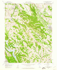 1959 Las Trampas Ridge1960 Print · USGSContra Costa County undergoes a suburban transformation in the late fifties as residential valleys expand toward the hills. Trace mid-century development near St Marys College, the Southern Pacific Railroad, and the Upper San Leandro Reservoir.5 unique versions available
 - 1959 Map of Concord, 1961 Print
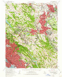 1959 Concord1961 Print · USGSThe East Bay's mid-century expansion is on full display here as suburban growth reaches into the interior valleys and ridges. Genealogists and local historians can trace legacy sites like Lafayette Cem, the small settlement of Eastport, and the campus of St Marys College.2 unique versions available
End of results
Showing maps 1-7 of 7
Top cities near Danville
- Oakland historical maps
- Fremont historical maps
- Hayward historical maps
- Concord historical maps
- Antioch historical maps
- San Leandro historical maps
See more
Top neighborhoods of Danville
- Sycamore Homes historical maps
- Brookview historical maps
- Northridge Estates historical maps
- Windstream historical maps
- Anderson Ranch historical maps
- California Chateau historical maps
See more
Frequently asked questions
- What are the different types of historical maps available for Danville?
- What is the oldest map of Danville?
- Where can I purchase historical maps of Danville for my home or office?
- Where can I download high-res historical maps of Danville?
- Are there historical topographic maps available for Danville?
- Is there historical aerial imagery available for Danville?
- Where are historical maps of Danville sourced from?