1990s Maps of Lafayette, California
Explore 7 historic maps of Lafayette from the 1990s. These maps offer a rare glimpse into what life looked like during the 1990s — showing old roads, neighborhoods, homes, and landmarks that have changed or disappeared over time.
Whether you're researching your family's past, planning a metal detecting trip, or studying how Lafayette's landscape evolved across the 1990s, these high-resolution maps are a powerful tool for exploring the history of this region.
- Focus on a specific era: All maps on this page are from the 1990s, giving you a focused view of this time period.
- See what’s changed: Compare century-old streets, trails, and buildings to today's modern landscape using overlays and satellite layers.
- Research with precision: Use these maps for genealogy, historical research, land use analysis, or educational projects.
- View, download, or print: Maps are fully viewable online in high resolution, and can be downloaded or printed for your own records.
Start exploring Lafayette's history through authentic maps from the 1990s. This is your window into the past.
Lafayette, CA maps
(7)- 1993 Map of Las Trampas Ridge, 1997 Print
 1993 Las Trampas Ridge1997 Print · USGSContra Costa and Alameda counties show a mix of dense suburban development and protected ridges in the 1990s. Trace the expansion of Lafayette and Moraga or locate landmarks like St Marys College and Upper San Leandro Reservoir.
 - 1993 Map of Walnut Creek, 1997 Print
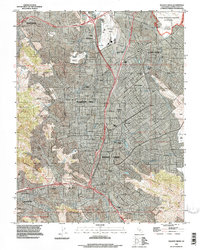 1993 Walnut Creek1997 Print · USGSThe East Bay's interior valleys were rapidly maturing in the early nineties, balancing suburban growth with historic land grants. Genealogists and local historians can trace family locations near Lafayette Cemetery, Buchanan Field, and Diablo Valley College.
 - 1993 Map of Briones Valley, 1997 Print
 1993 Briones Valley1997 Print · USGSContra Costa County in the early nineties reveals a landscape of high ridges and critical water infrastructure between expanding suburban centers. Trace the historical borders of the John Muir National Historic Site and the rugged peaks surrounding Briones Reservoir and Orinda Village.
 - 1995 Map of Briones Valley, 1999 Print
 1995 Briones Valley1999 Print · USGSContra Costa County in the 1990s shows a landscape of protected ridges and expanding valley settlements. Local historians can trace family land across Rancho El Sobrante or locate landmarks like the John Muir National Historic Site and Orinda Village.
 - 1995 Map of Walnut Creek, 1999 Print
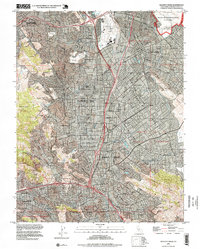 1995 Walnut Creek1999 Print · USGSContra Costa County at the peak of its late-twentieth-century growth shows a bustling network of suburban centers and industrial hubs. Genealogists and local researchers can trace family sites at Lafayette Cemetery and St Stephen Cem, or locate landmarks like Buchanan Field and Sparkle.
 - 1995 Map of Las Trampas Ridge, 1999 Print
 1995 Las Trampas Ridge1999 Print · USGSContra Costa County at the end of the century shows a unique balance between the developing San Ramon Valley and the protected heights of Las Trampas Ridge. Genealogists and hikers can trace the geography around St Marys College, Brown Ranch, and the Oakland Zoo in Knowland Park.
 - 1997 Map of Oakland East
 1997 Oakland East1997 Print · USGSThe East Bay waterfront and hills are captured here in the late 1990s as the urban corridor meets the ridge. Trace historic sites like Mountain View Cemetery, the University of California, and the Coast Guard Alameda Base.
End of results
Showing maps 1-7 of 7
Top cities near Lafayette
- San Francisco historical maps
- Oakland historical maps
- Hayward historical maps
- Concord historical maps
- Vallejo historical maps
- Berkeley historical maps
See more
Top neighborhoods of Lafayette
Frequently asked questions
- What are the different types of historical maps available for Lafayette?
- What is the oldest map of Lafayette?
- Where can I purchase historical maps of Lafayette for my home or office?
- Where can I download high-res historical maps of Lafayette?
- Are there historical topographic maps available for Lafayette?
- Is there historical aerial imagery available for Lafayette?
- Where are historical maps of Lafayette sourced from?