1940s Maps of Clovis, California
Explore 7 historic maps of Clovis from the 1940s. These maps offer a rare glimpse into what life looked like during the 1940s — showing old roads, neighborhoods, homes, and landmarks that have changed or disappeared over time.
Whether you're researching your family's past, planning a metal detecting trip, or studying how Clovis's landscape evolved across the 1940s, these high-resolution maps are a powerful tool for exploring the history of this region.
- Focus on a specific era: All maps on this page are from the 1940s, giving you a focused view of this time period.
- See what’s changed: Compare century-old streets, trails, and buildings to today's modern landscape using overlays and satellite layers.
- Research with precision: Use these maps for genealogy, historical research, land use analysis, or educational projects.
- View, download, or print: Maps are fully viewable online in high resolution, and can be downloaded or printed for your own records.
Start exploring Clovis's history through authentic maps from the 1940s. This is your window into the past.
Clovis, CA maps
(7)- 1946 Map of Friant, 1947 Print
 1946 Friant1947 Print · USGSThe San Joaquin River frontier was being reshaped by industrial engineering in the late 1940s. Genealogists and historians can trace the foundations of the regional water system at Friant Dam and find local landmarks like Gordon, Millerton Sch, and the Southern Pacific rail line.
 - 1946 Map of Clovis, 1955 Print
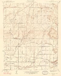
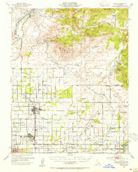 1946 Clovis1955 Print · USGSPost-war Fresno County comes to life as the newly completed Friant Dam transforms the valley landscape. Trace the origins of irrigation at Friant-Kern Canal or locate family landmarks like Hammer Field and Nees Colony Sch.
 - 1946 Map of Clovis, 1956 Print
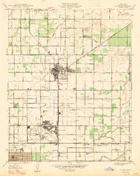
 1946 Clovis1956 Print · USGSThe Fresno area was undergoing a significant post-war shift in the late 1940s as military sites and irrigation networks defined the landscape. Genealogists and local historians can trace family-named schools and colonies like Kutner Colony, Tarpey, and Scandinavian Sch.
 - 1947 Map of Clovis
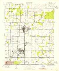
 1947 Clovis1947 Print · USGSAgriculture and aviation define this portion of the San Joaquin Valley just after the war years. Genealogists can trace the rural communities of Clovis and Pinedale, or locate family-named institutions like Garfield Sch and Temperance Sch near the sprawling Hammer Field.2 unique versions available
 - 1947 Map of Friant
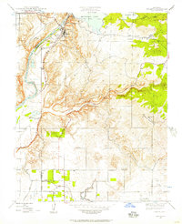
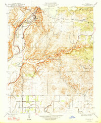 1947 Friant1947 Print · USGSThe foothills of Fresno and Madera counties come alive in the late 1940s as the massive Friant Dam reshapes the landscape. Local historians can trace the Southern Pacific rail line and discover rural landmarks like the Millerton Sch and Gordon.
 - 1947 Map of Round Mountain
 1947 Round Mountain1947 Print · USGSIn the mid-1940s, the Fresno County foothills transition into a rich agricultural corridor sustained by an intricate canal system. Researchers can trace historic family properties like Blue Jay Ranch or locate the rural Redbank Cem and Round Mountain Sch.2 unique versions available
 - 1948 Map of Fresno
 1948 Fresno1948 Print · USGSThe San Joaquin Valley and the High Sierra met during a period of rapid post-war growth and industrial expansion. Genealogists and researchers can trace family lines through small rail towns like Calwa City, find early aviation sites at Fresno-Chandler, or locate the Fresno Copper Mine.
End of results
Showing maps 1-7 of 7
Top cities near Clovis
- Fresno historical maps
- Reedley historical maps
- Sanger historical maps
- Fowler historical maps
- Minkler historical maps
Top neighborhoods of Clovis
Frequently asked questions
- What are the different types of historical maps available for Clovis?
- What is the oldest map of Clovis?
- Where can I purchase historical maps of Clovis for my home or office?
- Where can I download high-res historical maps of Clovis?
- Are there historical topographic maps available for Clovis?
- Is there historical aerial imagery available for Clovis?
- Where are historical maps of Clovis sourced from?