1980s Maps of Crabtree, California
Explore 2 historic maps of Crabtree from the 1980s. These maps offer a rare glimpse into what life looked like during the 1980s — showing old roads, neighborhoods, homes, and landmarks that have changed or disappeared over time.
Whether you're researching your family's past, planning a metal detecting trip, or studying how Crabtree's landscape evolved across the 1980s, these high-resolution maps are a powerful tool for exploring the history of this region.
- Focus on a specific era: All maps on this page are from the 1980s, giving you a focused view of this time period.
- See what’s changed: Compare century-old streets, trails, and buildings to today's modern landscape using overlays and satellite layers.
- Research with precision: Use these maps for genealogy, historical research, land use analysis, or educational projects.
- View, download, or print: Maps are fully viewable online in high resolution, and can be downloaded or printed for your own records.
Start exploring Crabtree's history through authentic maps from the 1980s. This is your window into the past.
Crabtree, CA maps
(2)- 1982 Map of Fresno, 1983 Print
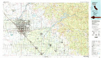 1982 Fresno1983 Print · USGSThe San Joaquin Valley's agricultural and urban landscape is captured here in the early eighties as Fresno expanded northward. Researchers can trace the rail lines of the Southern Pacific RR and identify landmarks like Raisin City and Kingsburg.2 unique versions available
 - 1987 Map of Verplank Ridge
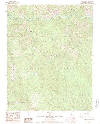 1987 Verplank Ridge1987 Print · USGSThe high Sierra and Sequoia forests meet along the Kings River in the late eighties, showing a wilderness crisscrossed by early logging and forest service tracks. Researchers can locate historical footprints at Rancheria (Site) and Goodmill (Site) or trace the rugged 4WD routes leading to the Delilah Lookout.2 unique versions available
End of results
Showing maps 1-2 of 2
Top cities near Crabtree
Frequently asked questions
- What are the different types of historical maps available for Crabtree?
- What is the oldest map of Crabtree?
- Where can I purchase historical maps of Crabtree for my home or office?
- Where can I download high-res historical maps of Crabtree?
- Are there historical topographic maps available for Crabtree?
- Is there historical aerial imagery available for Crabtree?
- Where are historical maps of Crabtree sourced from?