1940s Maps of Deer Crossing, California
Explore 3 historic maps of Deer Crossing from the 1940s. These maps offer a rare glimpse into what life looked like during the 1940s — showing old roads, neighborhoods, homes, and landmarks that have changed or disappeared over time.
Whether you're researching your family's past, planning a metal detecting trip, or studying how Deer Crossing's landscape evolved across the 1940s, these high-resolution maps are a powerful tool for exploring the history of this region.
- Focus on a specific era: All maps on this page are from the 1940s, giving you a focused view of this time period.
- See what’s changed: Compare century-old streets, trails, and buildings to today's modern landscape using overlays and satellite layers.
- Research with precision: Use these maps for genealogy, historical research, land use analysis, or educational projects.
- View, download, or print: Maps are fully viewable online in high resolution, and can be downloaded or printed for your own records.
Start exploring Deer Crossing's history through authentic maps from the 1940s. This is your window into the past.
Deer Crossing, CA maps
(3)- 1942 Map of Dunlap, 1962 Print
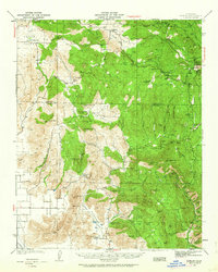 1942 Dunlap1962 Print · USGSThe Sierra Nevada foothills were a patchwork of family ranches and rural schoolhouses during the early 1940s. Genealogists can trace local roots at Auckland Ranch, Squaw Valley Sch, and the community at Miramonte.2 unique versions available
 - 1944 Map of Dunlap
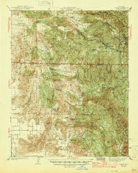 1944 Dunlap1944 Print · USGSThe Sierra Nevada foothills come alive in this mid-forties survey of the rugged Fresno and Tulare county line. Genealogists can trace early homesteads and family holdings like Auckland Ranch, Baker Ranch, and the Squaw Valley Sch.2 unique versions available
 - 1948 Map of Fresno
 1948 Fresno1948 Print · USGSThe San Joaquin Valley and the High Sierra met during a period of rapid post-war growth and industrial expansion. Genealogists and researchers can trace family lines through small rail towns like Calwa City, find early aviation sites at Fresno-Chandler, or locate the Fresno Copper Mine.
End of results
Showing maps 1-3 of 3
Top cities near Deer Crossing
- Yokuts Valley historical maps
- East Orosi historical maps
- Seville historical maps
- Yettem historical maps
Frequently asked questions
- What are the different types of historical maps available for Deer Crossing?
- What is the oldest map of Deer Crossing?
- Where can I purchase historical maps of Deer Crossing for my home or office?
- Where can I download high-res historical maps of Deer Crossing?
- Are there historical topographic maps available for Deer Crossing?
- Is there historical aerial imagery available for Deer Crossing?
- Where are historical maps of Deer Crossing sourced from?