1960s Maps of Fresno, California
Explore 13 historic maps of Fresno from the 1960s. These maps offer a rare glimpse into what life looked like during the 1960s — showing old roads, neighborhoods, homes, and landmarks that have changed or disappeared over time.
Whether you're researching your family's past, planning a metal detecting trip, or studying how Fresno's landscape evolved across the 1960s, these high-resolution maps are a powerful tool for exploring the history of this region.
- Focus on a specific era: All maps on this page are from the 1960s, giving you a focused view of this time period.
- See what’s changed: Compare century-old streets, trails, and buildings to today's modern landscape using overlays and satellite layers.
- Research with precision: Use these maps for genealogy, historical research, land use analysis, or educational projects.
- View, download, or print: Maps are fully viewable online in high resolution, and can be downloaded or printed for your own records.
Start exploring Fresno's history through authentic maps from the 1960s. This is your window into the past.
Fresno, CA maps
(13)- 1960 Map of Fresno
 1960 Fresno1960 Print · USGSThe San Joaquin Valley's mid-century agricultural boom meets the high peaks of the Sierra Nevada in this detailed survey. Genealogists and historians can trace the rail-driven growth of Fresno, Tulare, and Visalia or locate family roots in smaller towns like Raisin City and Calwa City.2 unique versions available
 - 1962 Map of Fresno, 1968 Print
 1962 Fresno1968 Print · USGSThe Central Valley and High Sierra meet in this mid-century survey, capturing the region's massive irrigation systems and mountain wilderness. Researchers can trace the rail corridors of the Southern Pacific and locate landmarks like the Tulare Lake Bed and Mount Whitney.3 unique versions available
 - 1963 Map of Kearney Park, 1964 Print
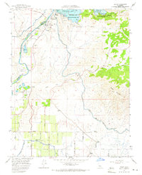
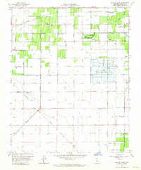 1963 Kearney Park1964 Print · USGSThe rural landscape west of Fresno in the early sixties reveals a transition from small rail stops to large-scale municipal infrastructure. Genealogists and historians can trace family-named roads and community landmarks like Rolinda, the Houghton Kearney Union School, and Kearney Park.2 unique versions available
 - 1963 Map of Fresno South, 1964 Print
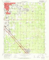
 1963 Fresno South1964 Print · USGSSouthern Fresno and the surrounding agricultural tracts are seen here in the early sixties as urban growth began to edge into the surrounding farm colonies. Researchers can trace family roots through numerous local landmarks, including Easton, Washington Colony Cem, and Oleander.4 unique versions available
 - 1963 Map of Fresno, 1966 Print
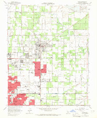
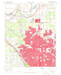
 1963 Fresno1966 Print · USGSFresno and its surrounding agricultural colonies are captured here during a period of significant mid-century development. Genealogists and researchers can trace family landmarks and rural roots at Raisin City, Caruthers, and the Fresno Memorial Gardens.
 - 1964 Map of Lanes Bridge, 1965 Print
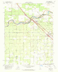
 1964 Lanes Bridge1965 Print · USGSMid-1960s Madera County comes into focus as irrigation and river geography shape the burgeoning rural and suburban landscape. Researchers can locate vanished schoolhouses like Webster Sch, trace the Madera Canal, and find old river crossings at Cobbs Ford.3 unique versions available
 - 1964 Map of Clovis, 1965 Print
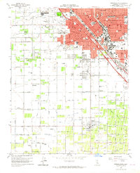
 1964 Clovis1965 Print · USGSThe Clovis and Fresno area undergoes significant mid-century suburban expansion as orchards give way to residential grids and college campus growth. Genealogists and local historians can trace the foundations of Fresno State College and search for family roots at Clovis Cem or the Tarpey Village area.5 unique versions available
 - 1964 Map of Friant, 1965 Print
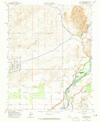
 1964 Friant1965 Print · USGSThe San Joaquin River valley was being reshaped by large-scale water projects in the mid-1960s. You can trace the engineering of the Friant Dam and Friant Kern Canal alongside local landmarks like Winchell Cove Cemetery and the Southern Pacific railroad line.3 unique versions available
 - 1964 Map of Herndon, 1965 Print
 1964 Herndon1965 Print · USGSIn the mid-sixties, the San Joaquin River valley north of Fresno served as a busy corridor for major railroads and industrial growth. Researchers can trace irrigation networks like the Herndon Canal and locate local landmarks including Teague Sch and the Divine Master Convent.2 unique versions available
 - 1964 Map of Malaga, 1965 Print
 1964 Malaga1965 Print · USGSSoutheast of Fresno in the mid-sixties, this area shows a landscape defined by dual rail lines and a complex irrigation network. Genealogists and historians can trace the growth of Malaga and Fowler, locating landmarks like Lone Star Sch and the US Experimental Station.3 unique versions available
 - 1965 Map of Fresno North, 1966 Print
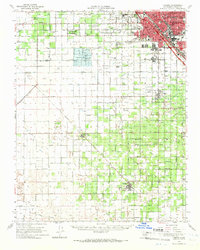
 1965 Fresno North1966 Print · USGSFresno was rapidly expanding northward toward the San Joaquin River during the mid-sixties. Genealogists and local historians can trace the development of neighborhood schools like Bullard High Sch and find long-standing landmarks such as Roeding Park and Pinedale.3 unique versions available
 - 1965 Map of Herndon, 1967 Print
 1965 Herndon1967 Print · USGSThe San Joaquin Valley's agricultural and urban expansion comes into focus during the mid-sixties as the Fresno suburbs push northward. Trace the development of Pinedale and Highway City or locate family sites near Mountain View Cem and Borden Station.
 - 1966 Map of Fresno
 1966 Fresno1966 Print · USGSCentral California in the mid-1960s showcases a high-production agricultural valley rising into the granite peaks of the High Sierra. Researchers can trace irrigation networks, rail spurs like the Southern Pacific, and landmarks from Mount Whitney to the Lemoore Naval Air Station.
End of results
Showing maps 1-13 of 13
Top cities near Fresno
- Clovis historical maps
- Madera historical maps
- Sanger historical maps
- Selma historical maps
- Parlier historical maps
- Fowler historical maps
See more
Top neighborhoods of Fresno
- Sunnyside historical maps
- Fresno Air Attack Base historical maps
- Fresno County Sheriffs Office historical maps
- Highway City historical maps
- Herndon historical maps
- Figarden historical maps
Frequently asked questions
- What are the different types of historical maps available for Fresno?
- What is the oldest map of Fresno?
- Where can I purchase historical maps of Fresno for my home or office?
- Where can I download high-res historical maps of Fresno?
- Are there historical topographic maps available for Fresno?
- Is there historical aerial imagery available for Fresno?
- Where are historical maps of Fresno sourced from?