1920s Maps of Figarden, Fresno
Explore 2 historic maps of Figarden from the 1920s. These maps offer a rare glimpse into what life looked like during the 1920s — showing old roads, neighborhoods, homes, and landmarks that have changed or disappeared over time.
Whether you're researching your family's past, planning a metal detecting trip, or studying how Figarden's landscape evolved across the 1920s, these high-resolution maps are a powerful tool for exploring the history of this region.
- Focus on a specific era: All maps on this page are from the 1920s, giving you a focused view of this time period.
- See what’s changed: Compare century-old streets, trails, and buildings to today's modern landscape using overlays and satellite layers.
- Research with precision: Use these maps for genealogy, historical research, land use analysis, or educational projects.
- View, download, or print: Maps are fully viewable online in high resolution, and can be downloaded or printed for your own records.
Start exploring Figarden's history through authentic maps from the 1920s. This is your window into the past.
Figarden, Fresno maps
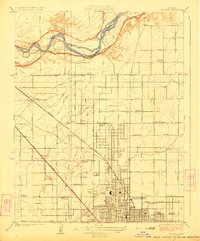
(2)- 1921 Map of Bullard
 1921 Bullard1921 Print · USGSNorth Fresno and the San Joaquin River corridor were undergoing rapid development in the early twenties as the city expanded toward the Madera County line. Genealogists and local historians can trace early neighborhood schools like Lincoln School and rail junctions such as Biola Junction or the Fresno Interurban.
 - 1923 Map of Bullard
 1923 Bullard1923 Print · USGSNorthern Fresno and the San Joaquin River corridor are captured here during the 1920s as the city expanded into the surrounding orchard lands. Researchers can trace early rail lines like the Fresno Interurban or locate family landmarks such as Bullard School and McKinley School.
End of results
Showing maps 1-2 of 2
Frequently asked questions
- What are the different types of historical maps available for Figarden?
- What is the oldest map of Figarden?
- Where can I purchase historical maps of Figarden for my home or office?
- Where can I download high-res historical maps of Figarden?
- Are there historical topographic maps available for Figarden?
- Is there historical aerial imagery available for Figarden?
- Where are historical maps of Figarden sourced from?