1940s Maps of Figarden, Fresno
Explore 3 historic maps of Figarden from the 1940s. These maps offer a rare glimpse into what life looked like during the 1940s — showing old roads, neighborhoods, homes, and landmarks that have changed or disappeared over time.
Whether you're researching your family's past, planning a metal detecting trip, or studying how Figarden's landscape evolved across the 1940s, these high-resolution maps are a powerful tool for exploring the history of this region.
- Focus on a specific era: All maps on this page are from the 1940s, giving you a focused view of this time period.
- See what’s changed: Compare century-old streets, trails, and buildings to today's modern landscape using overlays and satellite layers.
- Research with precision: Use these maps for genealogy, historical research, land use analysis, or educational projects.
- View, download, or print: Maps are fully viewable online in high resolution, and can be downloaded or printed for your own records.
Start exploring Figarden's history through authentic maps from the 1940s. This is your window into the past.
Figarden, Fresno maps
(3)- 1946 Map of Fresno North, 1955 Print
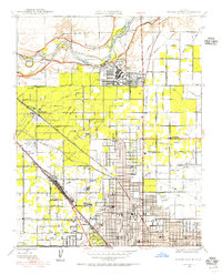 1946 Fresno North1955 Print · USGSNorthern Fresno and the San Joaquin River corridor appear here in the mid-1940s as the city expands toward the Madera County line. Researchers can trace the development of Camp Pinedale, the Army Air Forces Depot, and early neighborhoods near Figarden.
 - 1947 Map of Fresno North
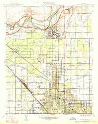 1947 Fresno North1947 Print · USGSNorth Fresno and the river bluffs are captured here just after the war as the city's northern suburbs began to take shape. Researchers can trace the development of Camp Pinedale, find early school sites like Wolters Sch, and locate vanished rail stops at Muscatel and Biola Junc.
 - 1948 Map of Fresno
 1948 Fresno1948 Print · USGSThe San Joaquin Valley and the High Sierra met during a period of rapid post-war growth and industrial expansion. Genealogists and researchers can trace family lines through small rail towns like Calwa City, find early aviation sites at Fresno-Chandler, or locate the Fresno Copper Mine.
End of results
Showing maps 1-3 of 3
Frequently asked questions
- What are the different types of historical maps available for Figarden?
- What is the oldest map of Figarden?
- Where can I purchase historical maps of Figarden for my home or office?
- Where can I download high-res historical maps of Figarden?
- Are there historical topographic maps available for Figarden?
- Is there historical aerial imagery available for Figarden?
- Where are historical maps of Figarden sourced from?