1920s Maps of Reedley, California
Explore 4 historic maps of Reedley from the 1920s. These maps offer a rare glimpse into what life looked like during the 1920s — showing old roads, neighborhoods, homes, and landmarks that have changed or disappeared over time.
Whether you're researching your family's past, planning a metal detecting trip, or studying how Reedley's landscape evolved across the 1920s, these high-resolution maps are a powerful tool for exploring the history of this region.
- Focus on a specific era: All maps on this page are from the 1920s, giving you a focused view of this time period.
- See what’s changed: Compare century-old streets, trails, and buildings to today's modern landscape using overlays and satellite layers.
- Research with precision: Use these maps for genealogy, historical research, land use analysis, or educational projects.
- View, download, or print: Maps are fully viewable online in high resolution, and can be downloaded or printed for your own records.
Start exploring Reedley's history through authentic maps from the 1920s. This is your window into the past.
Reedley, CA maps
(4)- 1922 Map of Trimmer
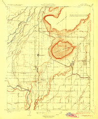
 1922 Trimmer1922 Print · USGSThe foothills of eastern Fresno County meet the San Joaquin Valley floor during a period of booming citrus and rail development. Researchers can trace early family-run rangelands and specialized sites like the Wahtoke Winery, the Sunnyside Mine, and the Sycamore Creek Indian School.
 - 1923 Map of Wahtoke
 1923 Wahtoke1923 Print · USGSFresno County’s eastern valley floor is shown during its early twentieth-century agricultural expansion, centered on the Kings River and the rising slopes of Campbell Mountain. Researchers can trace the legacy of local viticulture at the Wahtoke Winery or locate vanished rural schoolhouses like Great Western School and Wahtoke School.
 - 1924 Map of Reedley
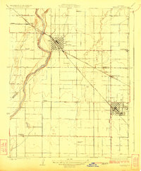 1924 Reedley1924 Print · USGSIn the fertile San Joaquin Valley during the 1920s, the fruit-growing region hummed with activity along the Kings River. Genealogists and historians can trace the development of Reedley and Dinuba while locating rural landmarks like Smith Mountain School and the Advent Church.
 - 1924 Map of Dinuba
 1924 Dinuba1924 Print · USGSThe Central Valley meets the Sierra foothills in the early twenties, showing a landscape defined by new canals and citrus groves. Genealogists can locate family holdings like Stair Ranch and dozens of country schools, including the Sycamore Creek Indian School and Great Western School.5 unique versions available
End of results
Showing maps 1-4 of 4
Top cities near Reedley
- Fresno historical maps
- Clovis historical maps
- Sanger historical maps
- Selma historical maps
- Dinuba historical maps
- Parlier historical maps
See more
Frequently asked questions
- What are the different types of historical maps available for Reedley?
- What is the oldest map of Reedley?
- Where can I purchase historical maps of Reedley for my home or office?
- Where can I download high-res historical maps of Reedley?
- Are there historical topographic maps available for Reedley?
- Is there historical aerial imagery available for Reedley?
- Where are historical maps of Reedley sourced from?