1960s Maps of San Joaquin, California
Explore 3 historic maps of San Joaquin from the 1960s. These maps offer a rare glimpse into what life looked like during the 1960s — showing old roads, neighborhoods, homes, and landmarks that have changed or disappeared over time.
Whether you're researching your family's past, planning a metal detecting trip, or studying how San Joaquin's landscape evolved across the 1960s, these high-resolution maps are a powerful tool for exploring the history of this region.
- Focus on a specific era: All maps on this page are from the 1960s, giving you a focused view of this time period.
- See what’s changed: Compare century-old streets, trails, and buildings to today's modern landscape using overlays and satellite layers.
- Research with precision: Use these maps for genealogy, historical research, land use analysis, or educational projects.
- View, download, or print: Maps are fully viewable online in high resolution, and can be downloaded or printed for your own records.
Start exploring San Joaquin's history through authentic maps from the 1960s. This is your window into the past.
San Joaquin, CA maps
(3)- 1963 Map of Kerman, 1965 Print
 1963 Kerman1965 Print · USGSFresno County's agricultural heartland is documented here in the early sixties as a complex network of irrigation and rail. Researchers can trace the lineage of water and transport through the James Bypass, the Southern Pacific line, and local sites like Traction Ranch or the Raisin City Oil Field.2 unique versions available
 - 1963 Map of San Joaquin, 1965 Print
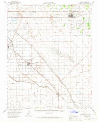
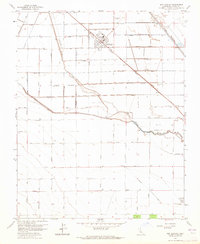 1963 San Joaquin1965 Print · USGSSan Joaquin and the surrounding Fresno County acreage are shown here at the height of the valley's mid-century agricultural boom. Researchers can trace the Southern Pacific Railroad corridor, find industrial markers like the Cotton Gin, and locate numerous Oil Wells and Gas Wells scattered across the county-named grid.
 - 1965 Map of Santa Cruz, 1968 Print
 1965 Santa Cruz1968 Print · USGSThe Central Coast and San Joaquin Valley meet here during the mid-sixties, capturing the growth of agricultural and coastal hubs. Trace the historic Southern Pacific RR lines and locate sites like the Presidio of Monterey or Pinnacles National Monument.
End of results
Showing maps 1-3 of 3
Top cities near San Joaquin
Frequently asked questions
- What are the different types of historical maps available for San Joaquin?
- What is the oldest map of San Joaquin?
- Where can I purchase historical maps of San Joaquin for my home or office?
- Where can I download high-res historical maps of San Joaquin?
- Are there historical topographic maps available for San Joaquin?
- Is there historical aerial imagery available for San Joaquin?
- Where are historical maps of San Joaquin sourced from?