1910s Maps of Orland, California
Explore 2 historic maps of Orland from the 1910s. These maps offer a rare glimpse into what life looked like during the 1910s — showing old roads, neighborhoods, homes, and landmarks that have changed or disappeared over time.
Whether you're researching your family's past, planning a metal detecting trip, or studying how Orland's landscape evolved across the 1910s, these high-resolution maps are a powerful tool for exploring the history of this region.
- Focus on a specific era: All maps on this page are from the 1910s, giving you a focused view of this time period.
- See what’s changed: Compare century-old streets, trails, and buildings to today's modern landscape using overlays and satellite layers.
- Research with precision: Use these maps for genealogy, historical research, land use analysis, or educational projects.
- View, download, or print: Maps are fully viewable online in high resolution, and can be downloaded or printed for your own records.
Start exploring Orland's history through authentic maps from the 1910s. This is your window into the past.
Orland, CA maps
(2)- 1914 Map of Kirkwood
 1914 Kirkwood1914 Print · USGSThe northern Sacramento Valley's agricultural transition is on display here in the years before the Great War. Genealogists and researchers can trace early rail sidings and water networks like Kirkwood, Malton, and the Lemon Home Colony Canal.
 - 1914 Map of Orland
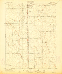 1914 Orland1914 Print · USGSGlenn County agriculture and rail travel are captured in the early twentieth century, centered on the growing town of Orland. Genealogists and historians can trace property lines and transport routes near Greenwood and the Southern Pacific Woodland Line.
End of results
Showing maps 1-2 of 2
Top cities near Orland
- Corning historical maps
- Willows historical maps
- Rancho Tehama Reserve historical maps
- Vina historical maps
Frequently asked questions
- What are the different types of historical maps available for Orland?
- What is the oldest map of Orland?
- Where can I purchase historical maps of Orland for my home or office?
- Where can I download high-res historical maps of Orland?
- Are there historical topographic maps available for Orland?
- Is there historical aerial imagery available for Orland?
- Where are historical maps of Orland sourced from?