1910s Maps of Willows, California
Explore 2 historic maps of Willows from the 1910s. These maps offer a rare glimpse into what life looked like during the 1910s — showing old roads, neighborhoods, homes, and landmarks that have changed or disappeared over time.
Whether you're researching your family's past, planning a metal detecting trip, or studying how Willows's landscape evolved across the 1910s, these high-resolution maps are a powerful tool for exploring the history of this region.
- Focus on a specific era: All maps on this page are from the 1910s, giving you a focused view of this time period.
- See what’s changed: Compare century-old streets, trails, and buildings to today's modern landscape using overlays and satellite layers.
- Research with precision: Use these maps for genealogy, historical research, land use analysis, or educational projects.
- View, download, or print: Maps are fully viewable online in high resolution, and can be downloaded or printed for your own records.
Start exploring Willows's history through authentic maps from the 1910s. This is your window into the past.
Willows, CA maps
(2)- 1917 Map of Lyman
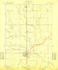 1917 Lyman1917 Print · USGSGlenn County agriculture was entering a transformative period of rail and water development during the late teens. Historians can trace the early rail junctions at Willows and follow the path of the Woodland Line and the Irrigation Canal.2 unique versions available
 - 1917 Map of Logandale
 1917 Logandale1917 Print · USGSThe northern Sacramento Valley during the early twentieth century shows an emerging agricultural grid shaped by water and rail. Researchers can trace the path of the Southern Pacific Woodland Line through Logandale and locate the path of the Central Irrigation Canal.
End of results
Showing maps 1-2 of 2
Top cities near Willows
Frequently asked questions
- What are the different types of historical maps available for Willows?
- What is the oldest map of Willows?
- Where can I purchase historical maps of Willows for my home or office?
- Where can I download high-res historical maps of Willows?
- Are there historical topographic maps available for Willows?
- Is there historical aerial imagery available for Willows?
- Where are historical maps of Willows sourced from?