1960s Maps of Capetown, California
Explore 2 historic maps of Capetown from the 1960s. These maps offer a rare glimpse into what life looked like during the 1960s — showing old roads, neighborhoods, homes, and landmarks that have changed or disappeared over time.
Whether you're researching your family's past, planning a metal detecting trip, or studying how Capetown's landscape evolved across the 1960s, these high-resolution maps are a powerful tool for exploring the history of this region.
- Focus on a specific era: All maps on this page are from the 1960s, giving you a focused view of this time period.
- See what’s changed: Compare century-old streets, trails, and buildings to today's modern landscape using overlays and satellite layers.
- Research with precision: Use these maps for genealogy, historical research, land use analysis, or educational projects.
- View, download, or print: Maps are fully viewable online in high resolution, and can be downloaded or printed for your own records.
Start exploring Capetown's history through authentic maps from the 1960s. This is your window into the past.
Capetown, CA maps
(2)- 1961 Map of Eureka
 1961 Eureka1961 Print · USGSThe Northern California coast and its deep redwood forests are mapped here at a time when the timber and rail industries defined the region. Researchers can trace historic family ranches and remote sites like Fort Dick, Table Bluff Lighthouse, and the Copper Creek Mine.2 unique versions available
 - 1969 Map of Capetown, 1974 Print
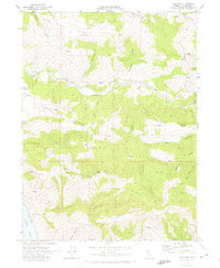 1969 Capetown1974 Print · USGSCoastal Humboldt County is documented here in the late sixties as the region's ranching and river-valley geography remained largely intact. Researchers can trace family-named landmarks and rural outposts like Green Pond Ranch, Graves, and the settlement of Capetown.2 unique versions available
End of results
Showing maps 1-2 of 2
Top cities near Capetown
- Fortuna historical maps
- Fortuna historical maps
- Ferndale historical maps
- Loleta historical maps
- Petrolia historical maps
Frequently asked questions
- What are the different types of historical maps available for Capetown?
- What is the oldest map of Capetown?
- Where can I purchase historical maps of Capetown for my home or office?
- Where can I download high-res historical maps of Capetown?
- Are there historical topographic maps available for Capetown?
- Is there historical aerial imagery available for Capetown?
- Where are historical maps of Capetown sourced from?